IMAGES TAKEN NEAR TO
Milngavie, GLASGOW, G62 8LB
Introduction
This page details the photographs taken nearby to G62 8LB by members of the Geograph project.
The Geograph project started in 2005 with the aim of publishing, organising and preserving representative images for every square kilometre of Great Britain, Ireland and the Isle of Man.

There are currently over 7.5m images from over14,400 individuals and you can help contribute to the project by visiting https://www.geograph.org.uk
Image Map
Images are licensed for reuse under creativecommons.org/licenses/by-sa/2.0
Notes
- Clicking on the map will re-center to the selected point.
- The higher the marker number, the further away the image location is from the centre of the postcode.
Image Listing (17 Images Found)
Images are licensed for reuse under creativecommons.org/licenses/by-sa/2.0
Image
Details
Distance
1
Milepost on A81
This milepost is adjacent to the grounds of Craigmaddie House.
Image: © Mark Nightingale
Taken: 7 Dec 2007
0.08 miles
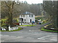
2
Craigmaddie House
In the centre of the picture; In the middle ages Craigmaddie was owned by the powerful Galbraiths of Baldernock, and there are ruins of an old castle. Glasgow's Lord Provost, James Black, purchased the estate at the end of the 18th century and built a cottage there. He then built the mansion, which was extended later. Henry Gordon acquired the estate in 1842, and made Craigmaddie the manor house for the Dougalston estate http://www.theglasgowstory.com/image/?inum=TGSB00256. Strathblane Road [A81] runs up the centre of the picture. The house was used as a hospital in the first World War. Craigmaddie Plantation is to the right.
Image: © M J Richardson
Taken: 23 Jul 2016
0.10 miles
3
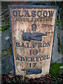
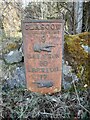
Old Milepost by the A81, west of Craigmaddie House
Glasgow curved cast iron plate by the A81, in parish of Strathblane (East Dunbartonshire), Craigmaddie House, set in stone wall opposite TP 9.
Inscription reads:- : GLASGOW / ROYAL EXCHANGE / 9 / {pointing hand} / BALFRON / 10 / ABERFOIL / 17 / {pointing hand} :
Surveyed
Milestone Society National ID: ED_GWAF09.
Image: © Milestone Society
Taken: Unknown
0.10 miles
4
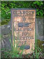
Milepost, Craigmaddie
Beside the A81.
GLASGOW
ROYAL EXCHANGE
9
BALFRON
10
ABERFOIL
17
Image: © Richard Sutcliffe
Taken: 18 Apr 2023
0.10 miles
5
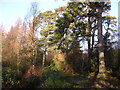
Craigmaddie Plantation
Mature Scots Pines amongst much newer fir trees
Image: © Chris Upson
Taken: 24 Dec 2005
0.12 miles
6
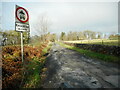
Bankend
The road leads from the A81 (immediately behind the photographer) to Mugdock village, but is for access only by vehicles.
Image: © Richard Sutcliffe
Taken: 18 Apr 2023
0.14 miles
7
![Easterton of Mugdock [2]](https://s0.geograph.org.uk/geophotos/02/68/00/2680068_01be8a50_120x120.jpg)
Easterton of Mugdock [2]
View along road towards Strathblane Road.
Image: © Robert Murray
Taken: 1 Nov 2011
0.14 miles
8
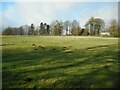
Molehills in a field
Beside the A81. Easterton House can be seen through the trees on the right.
Image: © Richard Sutcliffe
Taken: 18 Apr 2023
0.15 miles
9
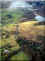
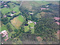
Craigmaddie from the air
The A81 Strathblane Road runs vertically through the scene.
Image: © Thomas Nugent
Taken: 24 Jan 2020
0.17 miles
10
South Lodge
The original lodge building Image was completely demolished in 2017 and replaced by this new house.
Image: © Richard Sutcliffe
Taken: 18 Apr 2023
0.19 miles