IMAGES TAKEN NEAR TO
Campsie Drive, GLASGOW, G62 8HY
Introduction
This page details the photographs taken nearby to Campsie Drive, G62 8HY by members of the Geograph project.
The Geograph project started in 2005 with the aim of publishing, organising and preserving representative images for every square kilometre of Great Britain, Ireland and the Isle of Man.

There are currently over 7.5m images from over14,400 individuals and you can help contribute to the project by visiting https://www.geograph.org.uk
Image Map
Images are licensed for reuse under creativecommons.org/licenses/by-sa/2.0
Notes
- Clicking on the map will re-center to the selected point.
- The higher the marker number, the further away the image location is from the centre of the postcode.
Image Listing (107 Images Found)
Images are licensed for reuse under creativecommons.org/licenses/by-sa/2.0
Image
Details
Distance
4
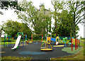
Play area beside the water tower
Because of the current Coronavirus (Covid-19) pandemic, the play equipment is not to be used.
Image: © Richard Sutcliffe
Taken: 10 Jun 2020
0.04 miles
5
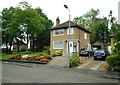
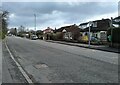
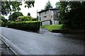
House on Campsie Drive
Behind the house is a concrete water tower.
Image: © Richard Sutcliffe
Taken: 10 Jun 2020
0.05 miles
6
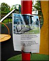
Update on Playgrounds
Notice beside play area by East Dunbartonshire Council requesting that people should not use the play areas or equipment due to the Coronavirus (Covid-19) pandemic.
Image: © Richard Sutcliffe
Taken: 10 Jun 2020
0.05 miles
7
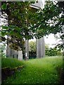
Water tower
Seen through the gate of the surrounding fence. The Scottish Water facility is labelled as Barloch DSR 1959.
Image: © Richard Sutcliffe
Taken: 10 Jun 2020
0.06 miles
8
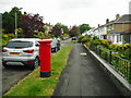
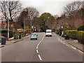
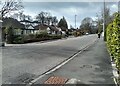
Campsie Drive
The pillar box is postbox number G62 1350D.
Image: © Richard Sutcliffe
Taken: 10 Jun 2020
0.06 miles
10
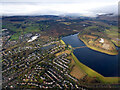
Milngavie and the reservoirs from the air
Craigmaddie Reservoir is on the right, with Mugdock beyond. Loch Lomond and Dumgoyne Hill are just visible in the distance.
Image: © Thomas Nugent
Taken: 24 Jan 2020
0.07 miles