IMAGES TAKEN NEAR TO
Mosswell Road, GLASGOW, G62 8HB
Introduction
This page details the photographs taken nearby to Mosswell Road, G62 8HB by members of the Geograph project.
The Geograph project started in 2005 with the aim of publishing, organising and preserving representative images for every square kilometre of Great Britain, Ireland and the Isle of Man.

There are currently over 7.5m images from over14,400 individuals and you can help contribute to the project by visiting https://www.geograph.org.uk
Image Map
Images are licensed for reuse under creativecommons.org/licenses/by-sa/2.0
Notes
- Clicking on the map will re-center to the selected point.
- The higher the marker number, the further away the image location is from the centre of the postcode.
Image Listing (149 Images Found)
Images are licensed for reuse under creativecommons.org/licenses/by-sa/2.0
Image
Details
Distance
1
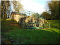
Mugdock and Craigmaddie Valve Chambers
Part of the infrastructure of the pipelines carrying water from Mugdock Reservoir to Glasgow. See Canmore https://canmore.org.uk/site/292274/glasgow-corporation-waterworks-mugdock-and-craigmaddie-valve-chamber.
Image: © Richard Sutcliffe
Taken: 5 Jan 2022
0.05 miles
2
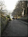
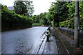
Commissioner's Road
Looking north towards the waterworks from the pedestrian access off Tannoch Drive. This road is closed to traffic and is a popular route for walkers to the nearby reservoirs.
Image: © Richard Sutcliffe
Taken: 27 May 2020
0.05 miles
3
Valve chambers
Part of the infrastructure of the pipeline carrying water from Mugdock Reservoir to Glasgow.
Image: © Richard Sutcliffe
Taken: 5 Jan 2022
0.06 miles
4
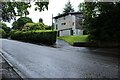
The Commissioner's Road
Looking down the hill towards Milngavie. The road gives access to the reservoirs, which are popular walking routes for dog-walkers and others.
Image: © Richard Sutcliffe
Taken: 5 Jan 2022
0.06 miles
6
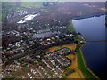
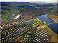
Milngavie from the air
Mugdock and Craigmaddie reservoirs are on the right.
Image: © Thomas Nugent
Taken: 3 Nov 2017
0.07 miles
7
Milngavie and the reservoirs from the air
Craigmaddie Reservoir is on the right, with Mugdock beyond. Loch Lomond and Dumgoyne Hill are just visible in the distance. Tannoch Loch is to the left of the reservoirs, amongst the houses.
Image: © Thomas Nugent
Taken: 24 Jan 2020
0.09 miles
8
Corner on the A81, Strathblane Road
Image: © Richard Sutcliffe
Taken: 26 Jul 2024
0.09 miles