IMAGES TAKEN NEAR TO
Buchanan Street, GLASGOW, G62 8DB
Introduction
This page details the photographs taken nearby to Buchanan Street, G62 8DB by members of the Geograph project.
The Geograph project started in 2005 with the aim of publishing, organising and preserving representative images for every square kilometre of Great Britain, Ireland and the Isle of Man.

There are currently over 7.5m images from over14,400 individuals and you can help contribute to the project by visiting https://www.geograph.org.uk
Image Map
Images are licensed for reuse under creativecommons.org/licenses/by-sa/2.0
Notes
- Clicking on the map will re-center to the selected point.
- The higher the marker number, the further away the image location is from the centre of the postcode.
Image Listing (662 Images Found)
Images are licensed for reuse under creativecommons.org/licenses/by-sa/2.0
Image
Details
Distance
1
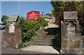
Gate pillars and steps, Cairns Church
The way into the Category B listed church http://portal.historicenvironment.scot/designation/LB37856 Image from Buchanan Street.
Image: © Richard Sutcliffe
Taken: 27 May 2020
0.01 miles
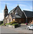
2
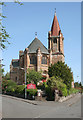
Cairns Church
Category B listed church http://portal.historicenvironment.scot/designation/LB37856, built in 1902 on Buchanan Street, Milngavie.
Image: © Richard Sutcliffe
Taken: 27 May 2020
0.04 miles
3
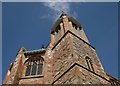
Tower, Cairns Church
It looks like the church tower is a chimney, but it is not smoke but a passing wispy cloud. The church is Category B listed http://portal.historicenvironment.scot/designation/LB37856 Image
Image: © Richard Sutcliffe
Taken: 27 May 2020
0.04 miles
5
Cairns Church
Category B listed church http://portal.historicenvironment.scot/designation/LB37856, built in 1902, but with more recent additions alongside on Buchanan Street, Milngavie.
Image: © Richard Sutcliffe
Taken: 27 May 2020
0.05 miles
6
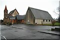
Cairns Church
Category B listed church http://portal.historicenvironment.scot/designation/LB37856, built in 1902, but with more recent additions alongside on Buchanan Street, Milngavie. Seen on a very dull Hogmanay afternoon.
Image: © Richard Sutcliffe
Taken: 31 Dec 2021
0.05 miles
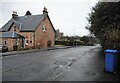
7
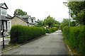
Kersland Drive
There is no pavement along this narrow residential street.
Image: © Richard Sutcliffe
Taken: 10 Jun 2020
0.06 miles
8
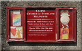
Notice board, Cairns Church
The notice board would usually have notices relating to church services etc. During the Coronavirus (Covid-19) pandemic, instead there are rainbows, showing support for the NHS. The middle notice on the left refers to the 100th birthday of Capt Tom Moore, who raised an amazing £32,796,696.73 for the NHS by walking around his garden in the lead-up to his birthday.
Image: © Richard Sutcliffe
Taken: 27 May 2020
0.06 miles
9
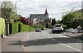
Cairns Drive
Looking toward Cairns Church on Buchanan Street. The church dates from 1902 and is Category B listed.
Image: © Richard Sutcliffe
Taken: 13 May 2020
0.06 miles
10
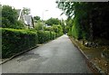
Kersland Drive
There is no pavement along this narrow residential street.
Image: © Richard Sutcliffe
Taken: 10 Jun 2020
0.07 miles