IMAGES TAKEN NEAR TO
Hillcrest Street, GLASGOW, G62 8AH
Introduction
This page details the photographs taken nearby to Hillcrest Street, G62 8AH by members of the Geograph project.
The Geograph project started in 2005 with the aim of publishing, organising and preserving representative images for every square kilometre of Great Britain, Ireland and the Isle of Man.

There are currently over 7.5m images from over14,400 individuals and you can help contribute to the project by visiting https://www.geograph.org.uk
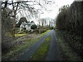
Image Map
Images are licensed for reuse under creativecommons.org/licenses/by-sa/2.0
Notes
- Clicking on the map will re-center to the selected point.
- The higher the marker number, the further away the image location is from the centre of the postcode.
Image Listing (758 Images Found)
Images are licensed for reuse under creativecommons.org/licenses/by-sa/2.0
Image
Details
Distance
1
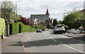
Cairns Drive
Looking toward Cairns Church on Buchanan Street. The church dates from 1902 and is Category B listed.
Image: © Richard Sutcliffe
Taken: 13 May 2020
0.02 miles
2
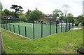
Netball court
Beside Milngavie Nursery, but for the use of Milngavie Primary School.
Image: © Richard Sutcliffe
Taken: 13 May 2020
0.04 miles
3
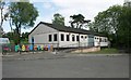
Milngavie Nursery
Situated just across the road from Milngavie Primary School, the nursery takes children aged 3 and 4 years old.
Currently closed due to the Coronavirus (Covid-19) pandemic.
Image: © Richard Sutcliffe
Taken: 13 May 2020
0.05 miles
4
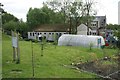
Polytunnel, Milngavie Nursery
The area behind the nursery is obviously used for outdoor activities. The nursery is currently closed due to the Coronavirus (Covid-19) pandemic.
Image: © Richard Sutcliffe
Taken: 13 May 2020
0.05 miles
5
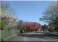
Spring blossom
On Cairns Drive, Milngavie.
Image: © Richard Sutcliffe
Taken: 20 Apr 2022
0.05 miles
6
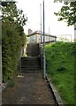
Steps up to Cairns Drive
The footpath leads from Mugdock Road to Cairns Drive.
Image: © Richard Sutcliffe
Taken: 13 May 2020
0.06 miles
7
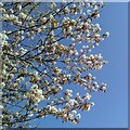
White blossom, blue sky
Blossom on a tree in Cairns Drive, Milngavie.
Image: © Richard Sutcliffe
Taken: 20 Apr 2022
0.06 miles
8
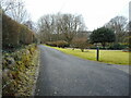
Barloch Avenue
Looking west, back towards Mugdock Road, from the end of Barloch Avenue.
Image: © Richard Sutcliffe
Taken: 1 Feb 2023
0.06 miles
9
Barloch Avenue
The road leads to Barloch House. Broombank is on the left.
Image: © Richard Sutcliffe
Taken: 1 Feb 2023
0.06 miles
10
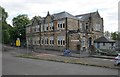
Milngavie Primary School
The original Milngavie Public School Image is behind this slightly later building, which is on Hillcrest Street.
Currently closed due to the Coronavirus (Covid-19) pandemic.
Image: © Richard Sutcliffe
Taken: 13 May 2020
0.06 miles