IMAGES TAKEN NEAR TO
Hillhead Street, GLASGOW, G62 8AF
Introduction
This page details the photographs taken nearby to Hillhead Street, G62 8AF by members of the Geograph project.
The Geograph project started in 2005 with the aim of publishing, organising and preserving representative images for every square kilometre of Great Britain, Ireland and the Isle of Man.

There are currently over 7.5m images from over14,400 individuals and you can help contribute to the project by visiting https://www.geograph.org.uk
Image Map
Images are licensed for reuse under creativecommons.org/licenses/by-sa/2.0
Notes
- Clicking on the map will re-center to the selected point.
- The higher the marker number, the further away the image location is from the centre of the postcode.
Image Listing (1003 Images Found)
Images are licensed for reuse under creativecommons.org/licenses/by-sa/2.0
Image
Details
Distance
1
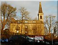
Old St Paul's Church, Milngavie
Now converted into flats, the church was designed by architects Leadbetter and Fairley in about 1898.
Image: © Richard Sutcliffe
Taken: 27 Nov 2019
0.01 miles
2
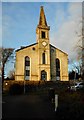
Old St Paul's Church, Milngavie
Now converted into flats, the church was designed by architects Leadbetter and Fairley in about 1898.
Image: © Richard Sutcliffe
Taken: 27 Nov 2019
0.01 miles
3
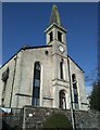
Old St Paul's Church, Milngavie
A difficult building to photograph, as there is a very inconvenient overhead cable which gets in the way if you move to the left. Now converted into flats, the church was designed by architects Leadbetter and Fairley in about 1898.
Image: © Richard Sutcliffe
Taken: 17 Mar 2021
0.01 miles
4
Old St Paul's Church
The church was designed by architects Leadbetter and Fairley in about 1898. Now converted into flats. Seen from Hillhead Street.
Image: © Richard Sutcliffe
Taken: 27 Apr 2023
0.01 miles
5
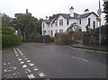
Mugdock Road
Looking past the end of Garvie & Co (restaurant-bar-bakery) towards the former St Paul's Church, now converted into flats.
Image: © Richard Sutcliffe
Taken: 2 Feb 2022
0.02 miles
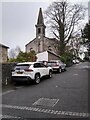
6
Houses on Hillhead Street, Milngavie
Beside the junction with Cairns Drive and Hillcrest Street. The former Old St Paul's Church Image can just be seen behind the trees.
Image: © Richard Sutcliffe
Taken: 22 Jul 2020
0.02 miles
7
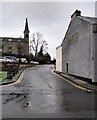
The bottom end of Hillhead Street, Milngavie
Looking up Hillhead Street from Station Road, after overnight snow.
Image: © Richard Sutcliffe
Taken: 9 Feb 2021
0.03 miles
8
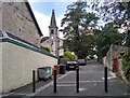
Hillhead Street
Looking up Hillhead Street from Station Road. The Old St Paul's Church (now flats) is to the left.
Image: © Richard Sutcliffe
Taken: 8 Aug 2022
0.03 miles
9
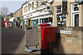
Station Road, Milngavie
Part of Milngavie's town centre; this small Dunbartonshire town is one of Glasgow's more prosperous suburbs.
Image: © Stephen McKay
Taken: 19 Mar 2008
0.03 miles
10
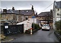
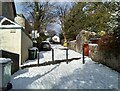
Looking towards Station Road
Looking down a narrow bit of road onto the pedestrianised Station Road. The low, white-painted building to the left is Body & Mind (a beauty salon). The other building on the left is Graeme Pharmacy.
Image: © Richard Sutcliffe
Taken: 2 Feb 2022
0.03 miles