IMAGES TAKEN NEAR TO
Balvie Road, GLASGOW, G62 7TB
Introduction
This page details the photographs taken nearby to Balvie Road, G62 7TB by members of the Geograph project.
The Geograph project started in 2005 with the aim of publishing, organising and preserving representative images for every square kilometre of Great Britain, Ireland and the Isle of Man.

There are currently over 7.5m images from over14,400 individuals and you can help contribute to the project by visiting https://www.geograph.org.uk
Image Map
Images are licensed for reuse under creativecommons.org/licenses/by-sa/2.0
Notes
- Clicking on the map will re-center to the selected point.
- The higher the marker number, the further away the image location is from the centre of the postcode.
Image Listing (343 Images Found)
Images are licensed for reuse under creativecommons.org/licenses/by-sa/2.0
Image
Details
Distance
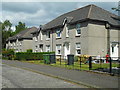
1
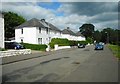
Houses on Balvie Road
The houses appear to have been painted recently.
Image: © Richard Sutcliffe
Taken: 3 Jun 2020
0.01 miles
3
Balvie Road
At the junction with Clober Road.
Image: © Richard Sutcliffe
Taken: 6 May 2020
0.03 miles
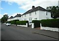
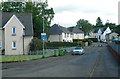
4
Ferguson Avenue
The houses at this part of Ferguson Avenue are set back and separated from the road by a semi-circle of grass and trees.
Image: © Richard Sutcliffe
Taken: 27 May 2022
0.04 miles
5
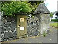
Electricity distribution box
Built into a wall at the end of Balvie Road.
Image: © Richard Sutcliffe
Taken: 27 May 2022
0.05 miles
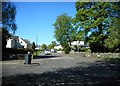
6
Knowe Street
The bollards mark the end of Knowe Street and the start of Ferguson Avenue.
Image: © Richard Sutcliffe
Taken: 3 Jun 2020
0.05 miles
7
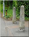
Bollards beside Clober Road
These two concrete and one older cast iron bollard are at the point where a path leads up to some of the houses which are set back from Clober Road.
Image: © Richard Sutcliffe
Taken: 3 Jun 2020
0.05 miles
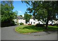
8
The end of Ferguson Avenue
The bollards mean that traffic cannot continue past this point into Knowe Street beyond.
Image: © Richard Sutcliffe
Taken: 3 Jun 2020
0.05 miles
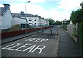
10
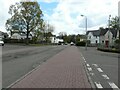
Extended pavement
The pink paviors between the different sections of the pavement, together with the road markings give a clear indication that pedestrians have right of way at this junction.
Image: © Richard Sutcliffe
Taken: 5 May 2021
0.06 miles