IMAGES TAKEN NEAR TO
Clober Road, GLASGOW, G62 7SW
Introduction
This page details the photographs taken nearby to Clober Road, G62 7SW by members of the Geograph project.
The Geograph project started in 2005 with the aim of publishing, organising and preserving representative images for every square kilometre of Great Britain, Ireland and the Isle of Man.

There are currently over 7.5m images from over14,400 individuals and you can help contribute to the project by visiting https://www.geograph.org.uk
Image Map
Images are licensed for reuse under creativecommons.org/licenses/by-sa/2.0
Notes
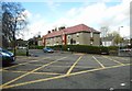
- Clicking on the map will re-center to the selected point.
- The higher the marker number, the further away the image location is from the centre of the postcode.
Image Listing (951 Images Found)
Images are licensed for reuse under creativecommons.org/licenses/by-sa/2.0
Image
Details
Distance
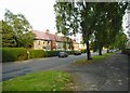
2
Houses on Clober Road
At the junction with Douglas Street.
Image: © Richard Sutcliffe
Taken: 14 Apr 2017
0.01 miles
3
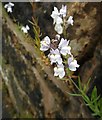
Growing in the wall
Pale toadflax (Linaria repens). This is one of many of these dainty looking plants, growing in the cracks in a wall at the end of Douglas Street, Milngavie.
Thanks to Anne Burgess for the identification.
Image: © Richard Sutcliffe
Taken: 8 Jul 2020
0.02 miles
4
Plants growing in a wall
Many of these pale toadflax (Linaria repens) plants Image are growing in cracks between the stones and mortar in this wall at the end of Douglas Street, Milngavie.
Thanks to Anne Burgess for the identification.
Image: © Richard Sutcliffe
Taken: 8 Jul 2020
0.02 miles
5
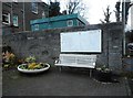
Seat and local maps
Despite Bearsden and Milngavie District Council ceasing to exist in 1996 (when East Dunbartonshire Council came into being), their name is still on top of the local maps beside the car park on Douglas Street.
Image: © Richard Sutcliffe
Taken: 31 Dec 2018
0.02 miles
6
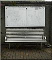
Old maps of Bearsden and Milngavie
Despite Bearsden and Milngavie District Council ceasing to exist in 1996 (when East Dunbartonshire Council came into being), their name is still on top of the old maps beside the car park on Douglas Street. It is interesting to compare these maps with current street maps to see how much has changed in the last 25+ years. See Image for a wider view of the location from 2018.
Image: © Richard Sutcliffe
Taken: 8 Jul 2020
0.02 miles
7
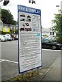
Pay and display
Sign at the entrance to the car park off Douglas Street, Milngavie. Until about three years ago, all the car parks in Milngavie were completely free. Then the local council introduced charges, but with the first two hours free. As you can see on the sign, you now have to pay for the first two hours too.
Image: © Richard Sutcliffe
Taken: 8 Jul 2020
0.02 miles
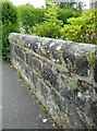
8
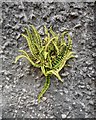
Maidenhair spleenwort (Asplenium trichomanes )
One of several plants growing in cracks in the harled wall beside the old maps of Bearsden and Milngavie Image
Image: © Richard Sutcliffe
Taken: 8 Jul 2020
0.02 miles
9
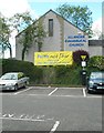
Allander Evangelical Church
The banner in front of the church encourages people to 'stay safe' during the Coronavirus (Covid-19) pandemic.
Image: © Richard Sutcliffe
Taken: 3 Jun 2020
0.03 miles
10
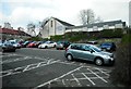
Allander Evangelical Church and Douglas Street car park
The car park is one of many in Milngavie, making it easy for shoppers to use the local shops. Until recently they were all completely free, but as the 'tickets here' sign behind the white car shows, charges for parking are now in place, although the first two hours are still free.
Image: © Richard Sutcliffe
Taken: 8 Apr 2017
0.03 miles