IMAGES TAKEN NEAR TO
Balvie Grove, GLASGOW, G62 7SF
Introduction
This page details the photographs taken nearby to Balvie Grove, G62 7SF by members of the Geograph project.
The Geograph project started in 2005 with the aim of publishing, organising and preserving representative images for every square kilometre of Great Britain, Ireland and the Isle of Man.

There are currently over 7.5m images from over14,400 individuals and you can help contribute to the project by visiting https://www.geograph.org.uk
Image Map
Images are licensed for reuse under creativecommons.org/licenses/by-sa/2.0
Notes
- Clicking on the map will re-center to the selected point.
- The higher the marker number, the further away the image location is from the centre of the postcode.
Image Listing (41 Images Found)
Images are licensed for reuse under creativecommons.org/licenses/by-sa/2.0
Image
Details
Distance
1
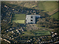
Douglas Academy from the air
On the western outskirts of Milngavie.
Image: © Thomas Nugent
Taken: 26 Feb 2023
0.08 miles
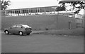
4
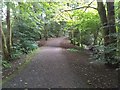
Earl's View
Leading to Balvie Grove.
Image: © Richard Sutcliffe
Taken: 19 Sep 2021
0.10 miles
5
Gymnasium, Douglas Academy
This is the gymnasium of the old Douglas Academy (a new school was built in 2009). Exact position uncertain.
Scanned from an AGFA colour transparency.
Image: © Richard Sutcliffe
Taken: Unknown
0.11 miles
6
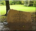
Welcome to Mains Estate Park
The stone at the start of the path through the park reads:
WELCOME TO
MAINS ESTATE PARK
THIS ENHANCED PLAY FACILITY HAS BEEN PROVIDED BY
MAINS ESTATE RESIDENTS' ASSOCIATION (MERA)
IN PARTNERSHIP WITH GENEROUS DONATIONS FROM
TARMAC, WREN, AWARDS FOR ALL,
MILNGAVIE COMMUNITY COUNCIL,
MILNGAVIE COUNCILLORS’ WARD FUND,
EAST DUNBARTONSHIRE COMMUNITY
GRANT SCHEME
The bottom of the inscription is hidden by mud.
Image: © Richard Sutcliffe
Taken: 19 Sep 2021
0.13 miles
7
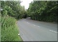
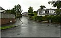
Corner on Craigton Road
Looking towards Milngavie.
Image: © Richard Sutcliffe
Taken: 19 Jul 2020
0.13 miles
8
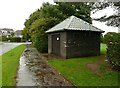
Building beside Falloch Road
This is apparently a 'gas governor'.
Image: © Richard Sutcliffe
Taken: 19 Sep 2021
0.15 miles
9
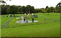
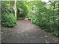
Play park
Within Mains Estate Park.
Image: © Richard Sutcliffe
Taken: 19 Sep 2021
0.15 miles
10

Treks & Tails
Dog walking service based in Milngavie.
Image: © Richard Sutcliffe
Taken: 19 Sep 2021
0.15 miles