IMAGES TAKEN NEAR TO
Hunter Road, GLASGOW, G62 7PX
Introduction
This page details the photographs taken nearby to Hunter Road, G62 7PX by members of the Geograph project.
The Geograph project started in 2005 with the aim of publishing, organising and preserving representative images for every square kilometre of Great Britain, Ireland and the Isle of Man.

There are currently over 7.5m images from over14,400 individuals and you can help contribute to the project by visiting https://www.geograph.org.uk
Image Map
Images are licensed for reuse under creativecommons.org/licenses/by-sa/2.0
Notes
- Clicking on the map will re-center to the selected point.
- The higher the marker number, the further away the image location is from the centre of the postcode.
Image Listing (104 Images Found)
Images are licensed for reuse under creativecommons.org/licenses/by-sa/2.0
Image
Details
Distance
1

Appropriate number plate
A 2020 McLaren 720S V8 S-A bearing an appropriate registration number for an online pharmacy!
Image: © Richard Sutcliffe
Taken: 8 May 2022
0.03 miles
3
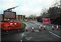
Road closed
Well it was when I took the photograph. When I came past again half an hour later, somebody had taken it on themselves to move some of the traffic cones and I saw several vehicles going through the 'closed' roundabout. I suppose it was Sunday - and nobody was doing any re-surfacing work...
Image: © Richard Sutcliffe
Taken: 6 Feb 2022
0.04 miles
5
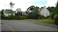
Craigdhu Farm Cottages
According to Rettie (Estate Agent)'s website, '...Converted in 2002 by Larsen & Ross Developments, Craigdhu Farm Cottages, formerly known as Craigdow Farm , was developed from a former farmhouse and steading...'
The building sits beside the Craigdhu Burn.
Image: © Richard Sutcliffe
Taken: 2 Jul 2020
0.06 miles
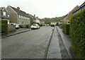
6
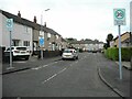
Hunter Place
Cul-de-sac off Hunter Road.
Image: © Richard Sutcliffe
Taken: 8 May 2022
0.07 miles
7
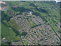
Milngavie from the air
The west side of Milngavie at the A809 Stockiemuir Road.
Image: © Thomas Nugent
Taken: 22 Jun 2015
0.07 miles
8
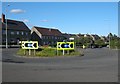
Roundabout on B8050, Milngavie
Roundabout on B8050 (Craigdhu Road) where it meets Hunter Road and Chestnut Lane.
East Dunbartonshire Council have sown a nice display of wild flowers in the middle.
Image: © Richard Sutcliffe
Taken: 7 Aug 2015
0.07 miles
9
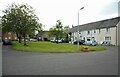
Roundabout, Milngavie
At the junction of Craigdhu Road and Hunter Road.
Image: © Richard Sutcliffe
Taken: 14 Apr 2020
0.07 miles
10
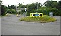
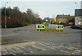
Roundabout on Craigdhu Road
The roundabout is on the B8050 where it turns to the left. Hunter Road is on the right and Chestnut Lane is straight on. Wild flowers were sown here about five years ago and continue to make a pleasing display in early summer.
Image: © Richard Sutcliffe
Taken: 2 Jul 2020
0.07 miles