IMAGES TAKEN NEAR TO
Ashburn Road, GLASGOW, G62 7PG
Introduction
This page details the photographs taken nearby to Ashburn Road, G62 7PG by members of the Geograph project.
The Geograph project started in 2005 with the aim of publishing, organising and preserving representative images for every square kilometre of Great Britain, Ireland and the Isle of Man.

There are currently over 7.5m images from over14,400 individuals and you can help contribute to the project by visiting https://www.geograph.org.uk
Image Map
Images are licensed for reuse under creativecommons.org/licenses/by-sa/2.0
Notes
- Clicking on the map will re-center to the selected point.
- The higher the marker number, the further away the image location is from the centre of the postcode.
Image Listing (95 Images Found)
Images are licensed for reuse under creativecommons.org/licenses/by-sa/2.0
Image
Details
Distance
2
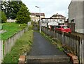
Steps up to Craigielea Crescent
From Ashburn Road.
Image: © Richard Sutcliffe
Taken: 19 Sep 2021
0.04 miles
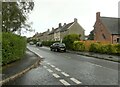
3
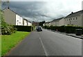
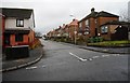
Ashburn Road
A suburban street in Milngavie.
Image: © Richard Sutcliffe
Taken: 14 Jan 2020
0.05 miles
5
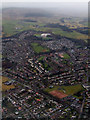
Milngavie from the air
The B8050 road runs diagonally through the lower half of the photo. The mist shrouded Kilpatrick Hills are in the distance.
Image: © Thomas Nugent
Taken: 4 Feb 2011
0.06 miles
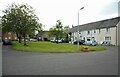
6
Hunter Place
Cul-de-sac off Hunter Road.
Image: © Richard Sutcliffe
Taken: 8 May 2022
0.06 miles
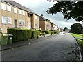
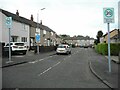
8
Ashburn Gardens
The street is a 20 MPH zone.
Image: © Richard Sutcliffe
Taken: 19 Sep 2021
0.07 miles
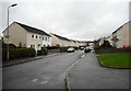
9
Craigielea Crescent
A suburban street in Milngavie.
Image: © Richard Sutcliffe
Taken: 14 Jan 2020
0.08 miles
10
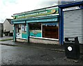
Carbeth Convenience Store
Corner shop on Carbeth Road.
Image: © Richard Sutcliffe
Taken: 19 Sep 2021
0.08 miles