IMAGES TAKEN NEAR TO
McGrigor Road, GLASGOW, G62 7LD
Introduction
This page details the photographs taken nearby to McGrigor Road, G62 7LD by members of the Geograph project.
The Geograph project started in 2005 with the aim of publishing, organising and preserving representative images for every square kilometre of Great Britain, Ireland and the Isle of Man.

There are currently over 7.5m images from over14,400 individuals and you can help contribute to the project by visiting https://www.geograph.org.uk
Image Map
Images are licensed for reuse under creativecommons.org/licenses/by-sa/2.0
Notes
- Clicking on the map will re-center to the selected point.
- The higher the marker number, the further away the image location is from the centre of the postcode.
Image Listing (68 Images Found)
Images are licensed for reuse under creativecommons.org/licenses/by-sa/2.0
Image
Details
Distance
1
NEW
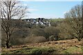
Distant houses
Houses on Crawford Road, McGrigor Road and Blackwood Road, seen from across the other side of the Allander Water. In the middle can be seen the roofs and ventilators of factory units on Cloberfield.
Image: © Richard Sutcliffe
Taken: 11 Mar 2025
0.04 miles
2
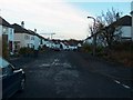
Crawford Road, Cloberfield, Milngavie
Image: © Andrew McEwan
Taken: 16 Nov 2005
0.05 miles
3
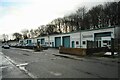
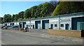
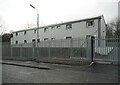
Business premises, Cloberfield
A block of nine units.
Image: © Richard Sutcliffe
Taken: 8 Feb 2022
0.09 miles
4
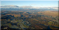
Milngavie Golf Club from the air
Strathblane is on the right, Loch Lomond is in the distance.
Image: © Thomas Nugent
Taken: 11 Dec 2017
0.10 miles
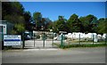
5
Business premises, Cloberfield
Because of the Coronavirus pandemic, only the veterinary clinic was open Image
Image: © Richard Sutcliffe
Taken: 6 May 2020
0.11 miles
6
Waiting to see the vet
A small dog and his owner waiting patiently outside the Avalon Veterinary Clinic on Cloberfield. Due to the Coronavirus pandemic, the clinic is running a much reduced service. According to their Facebook site, in the interest of social distancing, they are only allowing staff in the building. A member of staff takes your pet into the surgery while asking owners to remain outside.
Image: © Richard Sutcliffe
Taken: 6 May 2020
0.12 miles
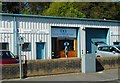
7
Allander Aggregates
Business on Cloberfield, supplying decorative stone, gravel and sand for landscaping and building for both trade and home owners. Currently closed due to the Coronavirus pandemic.
Image: © Richard Sutcliffe
Taken: 6 May 2020
0.12 miles
8
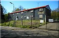
Closed-up building
Former business premises, now closed-up and (presumably) empty.
Image: © Richard Sutcliffe
Taken: 6 May 2020
0.12 miles
9
Refurbished building, Cloberfield
This building has recently been refurbished, although it is not clear if it is yet occupied. See the same building in 2020 Image
Image: © Richard Sutcliffe
Taken: 8 Feb 2022
0.13 miles
10
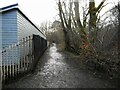
The official path
This footpath leads south from the bridge over the Allander Water (Staney Brig). It then heads southeast to join Stable Road and into Milngavie; or to the northwest towards Mugdock Country Park. An alternative unmade path following the Craigton Burn Image saves about 100 metres if heading to Mugdock.
Image: © Richard Sutcliffe
Taken: 8 Feb 2022
0.13 miles