IMAGES TAKEN NEAR TO
Carnedanns Road, GLASGOW, G62 7HE
Introduction
This page details the photographs taken nearby to Carnedanns Road, G62 7HE by members of the Geograph project.
The Geograph project started in 2005 with the aim of publishing, organising and preserving representative images for every square kilometre of Great Britain, Ireland and the Isle of Man.

There are currently over 7.5m images from over14,400 individuals and you can help contribute to the project by visiting https://www.geograph.org.uk
Image Map
Images are licensed for reuse under creativecommons.org/licenses/by-sa/2.0
Notes
- Clicking on the map will re-center to the selected point.
- The higher the marker number, the further away the image location is from the centre of the postcode.
Image Listing (28 Images Found)
Images are licensed for reuse under creativecommons.org/licenses/by-sa/2.0
Image
Details
Distance
1
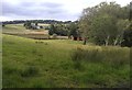
Field beside The Loan
The Loan is the road which crossed the picture from left to right just behind the small stable in the field. The houses in the distance are Craigton Cottages.
Image: © Richard Sutcliffe
Taken: 19 Jul 2020
0.03 miles
2
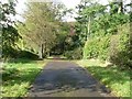
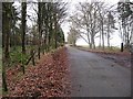
Carneddans Road
In the countryside between Milngavie and Craigton.
Image: © Stephen Sweeney
Taken: 3 Oct 2009
0.03 miles
3
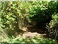
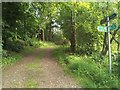
Barely visible public path
Were it not signposted, I would have walked right past it!
Image: © Stephen Sweeney
Taken: 3 Oct 2009
0.05 miles
4
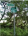
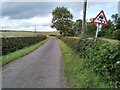
Direction signs
To the left Carneddans Road continues east southeast for 200 metres before becoming a footpath between fields, leading to Craigton Road and into Milngavie. To the right Carneddans Road runs west northwest for 250 metres to join The Loan. Turning left there takes you to Craigton Village on the A809. The other route is a footpath which comes out further east on The Loan beside the bridge over the Craigton Burn. Turning right, the road takes you past Laighpark, before eventually ending at Milngavie Golf Club.
Image: © Richard Sutcliffe
Taken: 19 Jul 2020
0.06 miles
6
Footpath to Carneddans Road
The direction signs show 'Clyde Coastal Path'. This might seem a bit strange so far inland, but the long distance path runs from the Kelly Burn (between Wemyss Bay and Skelmorlie) to Greenock, then across the Erskine Bridge to finish in Milngavie. It fills the gap between the Ayrshire Coastal Path and the West Highland Way. It is an essential link in the route from the Mull of Galloway to Cape Wrath.
Image: © Richard Sutcliffe
Taken: 19 Jul 2020
0.12 miles
7
The Loan
The road leads to Laighpark and Milngavie Golf Club. Both electricity pole and road sign have a lean to the right.
Image: © Richard Sutcliffe
Taken: 19 Jul 2020
0.12 miles
8
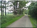
Carneddans Road
This road leads east southeast from The Loan to give access to five houses along its length.
Image: © Richard Sutcliffe
Taken: 19 Jul 2020
0.12 miles
9
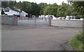
Craigton Industries
Situated beside the Craigton Burn, this was the site of the 19th century Craigton Bleach Works. Some of the original buildings survive, but have been repurposed. Today this is the home of Craigton Industries Ltd, suppliers of building, civil engineering, drainage and landscaping products.
Image: © Richard Sutcliffe
Taken: 19 Jul 2020
0.14 miles
10
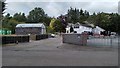
Craigton Industries
Situated beside the Craigton Burn, this was the site of the 19th century Craigton Bleach Works. Some of the original buildings survive, but have been repurposed. Today this is the home of Craigton Industries Ltd, suppliers of building, civil engineering, drainage and landscaping products.
Image: © Richard Sutcliffe
Taken: 19 Jul 2020
0.14 miles