IMAGES TAKEN NEAR TO
Southgate, GLASGOW, G62 6RB
Introduction
This page details the photographs taken nearby to Southgate, G62 6RB by members of the Geograph project.
The Geograph project started in 2005 with the aim of publishing, organising and preserving representative images for every square kilometre of Great Britain, Ireland and the Isle of Man.

There are currently over 7.5m images from over14,400 individuals and you can help contribute to the project by visiting https://www.geograph.org.uk
Image Map
Images are licensed for reuse under creativecommons.org/licenses/by-sa/2.0
Notes
- Clicking on the map will re-center to the selected point.
- The higher the marker number, the further away the image location is from the centre of the postcode.
Image Listing (722 Images Found)
Images are licensed for reuse under creativecommons.org/licenses/by-sa/2.0
Image
Details
Distance
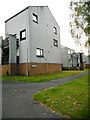
1
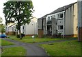
Properties on Southgate, Milngavie
Image: © Richard Sutcliffe
Taken: 17 Jun 2020
0.00 miles
2
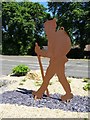
Outline sculpture of a walker
Outline sculpture of a walker on Milngavie Road in Milngavie just a few hundred metres from the southern start point of the West highland Way long distance path.
Image: © Philip Halling
Taken: 27 Jun 2019
0.02 miles
3
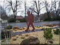
Sculpture of a walker, Milngavie
The figure of a walker is dedicated to the memory of the late Tom Hunter (1926-2016), who proposed the idea of the West Highland Way (from Milngavie to Fort William), which officially opened in 1980.
The figure (which was erected in 2019) was fabricated by Scott Associates Sculpture & Design Ltd on a concrete base constructed by MacColl Landscaping Ltd. The planting around the figure was done by Milngavie in Bloom.
Image: © Richard Sutcliffe
Taken: 13 Jan 2020
0.03 miles
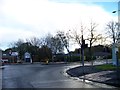
4
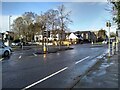
Traffic lights
The junction of Main Street (B8030) and Park Road (B8050).
Image: © Richard Sutcliffe
Taken: 30 Jan 2023
0.03 miles
5
Traffic lights on the B8030
Woodburn Way, the dual carriageway straight ahead was built in the 1970s to by-pass Milngavie's town centre, improving traffic flow and allowing the creation of pedestrian only areas beside the shops.
Image: © Richard Sutcliffe
Taken: 17 Jun 2020
0.03 miles
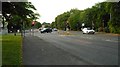
7
Junction of Park Road (B8050) and Main Street (B8030)
Image: © Elliott Simpson
Taken: 9 Nov 2013
0.04 miles
8
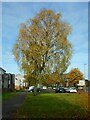
Autumn colours, Milngavie
Beside Main Street.
Image: © Richard Sutcliffe
Taken: 15 Oct 2020
0.04 miles
9
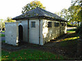
Public toilets, Lennox Park
The toilets closed in 1997 and have remained vacant ever since.
Image: © Richard Sutcliffe
Taken: 2 Oct 2020
0.04 miles
10
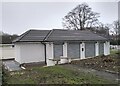
Former toilets, Lennox Park
The Rhododendron bushes between the building and Main Street have been cut down to ground level, so that the re-furbished former toilets are now more visible than they have for some time. Work continues on the new monoblock path outside.
Image: © Richard Sutcliffe
Taken: 22 Dec 2021
0.04 miles