IMAGES TAKEN NEAR TO
Riverside, GLASGOW, G62 6PL
Introduction
This page details the photographs taken nearby to Riverside, G62 6PL by members of the Geograph project.
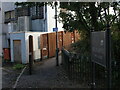
The Geograph project started in 2005 with the aim of publishing, organising and preserving representative images for every square kilometre of Great Britain, Ireland and the Isle of Man.

There are currently over 7.5m images from over14,400 individuals and you can help contribute to the project by visiting https://www.geograph.org.uk
Image Map
Images are licensed for reuse under creativecommons.org/licenses/by-sa/2.0
Notes
- Clicking on the map will re-center to the selected point.
- The higher the marker number, the further away the image location is from the centre of the postcode.
Image Listing (956 Images Found)
Images are licensed for reuse under creativecommons.org/licenses/by-sa/2.0
Image
Details
Distance
1
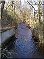
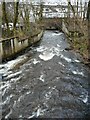
Allander Water
Seen from the bridge at Riverside.
Image: © Richard Sutcliffe
Taken: 17 Mar 2021
0.01 miles
2
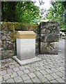
Home: Agnes Frame
One of a series of six way markers by Alex Allan titled ‘Home’, beside the West Highland Way.
agnes frame
ellangowan
mill worker
Image: © Richard Sutcliffe
Taken: 8 Jul 2020
0.02 miles
3
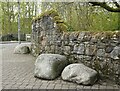
Boulders beside the wall
It's not clear why these boulders have been left where they are beside the wall, but they make an interesting feature.
Image: © Richard Sutcliffe
Taken: 5 May 2021
0.02 miles
4
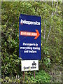
Sign for Indespension and Scottoiler
On Riverside, Milngavie.
Image: © Richard Sutcliffe
Taken: 5 May 2021
0.02 miles
5
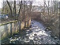
Allander Water
Looking downstream from the bridge at Riverside.
Image: © Richard Sutcliffe
Taken: 1 Feb 2023
0.03 miles
6
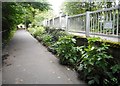
West Highland Way path
This part of the path running parallel with Ellangowan Road has an attractive flower border. This is maintained by Milngavie in Bloom and Bearsden and Milngavie Ramblers.
Image: © Richard Sutcliffe
Taken: 8 Jul 2020
0.03 miles
7
Allander Water
Looking downstream from the bridge at Riverside.
Image: © Richard Sutcliffe
Taken: 17 Mar 2021
0.03 miles
8
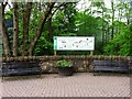
Milngavie, West Highland Way
The noticeboard at the beginning of the path a short distance from the official starting point in Douglas Street.
Image: © Robert Murray
Taken: 7 May 2011
0.03 miles
9
First few steps of the West Highland Way
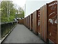
This ramp leads down from Douglas Street to a small car park and on to the early stages of the West Highland Way long-distance path (https://www.geograph.org.uk/snippet/15448) - well, early for the majority who follow it south to north. The panels against the wall list some of the highlights awaiting West Highland Way walkers in the next 96 miles.
Image: © Alec MacKinnon
Taken: 2 Oct 2020
0.03 miles
10
Start of the West Highland Way
A series of cut-out rusty steel panels illustrate highlights along the length of the West Highland Way route. Nearest is a panel showing Dumgoyne and Glengoyne Distillery, which is 12 miles into the route.
Image: © Richard Sutcliffe
Taken: 5 May 2021
0.03 miles