IMAGES TAKEN NEAR TO
Park Road, GLASGOW, G62 6PJ
Introduction
This page details the photographs taken nearby to Park Road, G62 6PJ by members of the Geograph project.
The Geograph project started in 2005 with the aim of publishing, organising and preserving representative images for every square kilometre of Great Britain, Ireland and the Isle of Man.

There are currently over 7.5m images from over14,400 individuals and you can help contribute to the project by visiting https://www.geograph.org.uk
Image Map
Images are licensed for reuse under creativecommons.org/licenses/by-sa/2.0
Notes
- Clicking on the map will re-center to the selected point.
- The higher the marker number, the further away the image location is from the centre of the postcode.
Image Listing (994 Images Found)
Images are licensed for reuse under creativecommons.org/licenses/by-sa/2.0
Image
Details
Distance
1
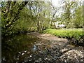
Allander Water and Gavin's Mill
After a long dry spell, the Allander Water is running low through Lennox Park. The mill Image is Category B listed.
Image: © Richard Sutcliffe
Taken: 28 Apr 2021
0.02 miles
2
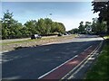
Woodburn Way
The B8030, Woodburn Way bypasses the centre of Milngavie, which is pedestrianised.
Image: © Richard Sutcliffe
Taken: 29 May 2023
0.02 miles
3
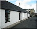
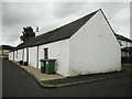
Corbie-Ha, Ashfield Road
A stone farm cottage, the original farmhouse for Milngavie Farm, dating from around 1800 and believed to be the oldest house remaining in Milngavie. It is Category B listed, and described as 'Picturesque 1 storey range; limewashed; ridge slate roof' according to Historical Environment Scotland.
The building was due to be demolished in 1966 when the last tenants moved out, but it was acquired by the Milngavie Pipe Band in 1972, who still use it. The outside of the building was repainted in 2013.
Image: © Richard Sutcliffe
Taken: 14 Apr 2017
0.02 miles
4
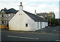
Corbie-Ha, Ashfield Road
A stone farm cottage, the original farmhouse for Milngavie Farm, dating from around 1800 and believed to be the oldest house remaining in Milngavie. It is Category B listed, and described as 'Picturesque 1 storey range; limewashed; ridge slate roof' according to Historical Environment Scotland.
The building was due to be demolished in 1966 when the last tenants moved out, but it was acquired by the Milngavie Pipe Band in 1972, who still use it. The outside of the building was repainted in 2013.
Park Road is in the foreground.
Image: © Richard Sutcliffe
Taken: 14 Apr 2017
0.02 miles
5
Corbie-Ha, 12 Ashfield Road
A stone farm cottage, the original farmhouse for Milngavie Farm, dating from around 1800 and believed to be the oldest house remaining in Milngavie. It is Category B listed, and described as 'Picturesque 1 storey range; limewashed; ridge slate roof' according to Historical Environment Scotland.
The building was due to be demolished in 1966 when the last tenants moved out, but it was acquired by the Milngavie Pipe Band in 1972, who still use it.
Image: © Richard Sutcliffe
Taken: 20 Aug 2020
0.02 miles
6
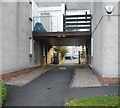
The path to flats on Park Avenue
The path leads underneath part of the building from Park Road (behind the photographer) to Park Avenue.
Image: © Richard Sutcliffe
Taken: 17 Jun 2020
0.02 miles
7
Corbie-Ha, 12 Ashfield Road
A stone farm cottage, the original farmhouse for Milngavie Farm, dating from around 1800 and believed to be the oldest house remaining in Milngavie. It is Category B listed, and described as 'Picturesque 1 storey range; limewashed; ridge slate roof' according to Historical Environment Scotland.
The building was due to be demolished in 1966 when the last tenants moved out, but it was acquired by the Milngavie Pipe Band in 1972, who still use it.
Image: © Richard Sutcliffe
Taken: 17 Jun 2020
0.02 miles
8
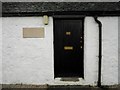
Door to Corbie-Ha
Corbie-Ha is a stone farm cottage, the original farmhouse for Milngavie Farm, dating from around 1800 and believed to be the oldest house remaining in Milngavie. It is Category B listed, and described as 'Picturesque 1 storey range; limewashed; ridge slate roof' according to Historical Environment Scotland.
The building was due to be demolished in 1966 when the last tenants moved out, but it was acquired by the Milngavie Pipe Band in 1972, who still use it.
The pale sandstone name plaque beside the door has been added recently. It reads:
corbie ha'
circa 1800
Image: © Richard Sutcliffe
Taken: 20 Aug 2020
0.02 miles
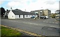
9
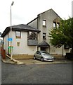
Flats, Ashfield Road, Milngavie
The flats occupy the site of the former telephone exchange. It was replaced by a larger modern building close by in the 1970s. The flats incorporate architectural elements of the old building, including a keystone dated 1936 with the cipher of Edward VIII Image
Image: © Richard Sutcliffe
Taken: 20 Aug 2020
0.02 miles
10
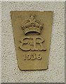
Architectural detail
This keystone, dated 1936 with the cipher of Edward VIII, is from the former telephone exchange which used to stand on this site, which was replaced by a larger modern building close by in the 1970s. The flats which now occupy the site Image incorporate architectural elements from the old building, including the keystone.
Image: © Richard Sutcliffe
Taken: 20 Aug 2020
0.02 miles