IMAGES TAKEN NEAR TO
Braeside Avenue, GLASGOW, G62 6NN
Introduction
This page details the photographs taken nearby to Braeside Avenue, G62 6NN by members of the Geograph project.
The Geograph project started in 2005 with the aim of publishing, organising and preserving representative images for every square kilometre of Great Britain, Ireland and the Isle of Man.

There are currently over 7.5m images from over14,400 individuals and you can help contribute to the project by visiting https://www.geograph.org.uk
Image Map
Images are licensed for reuse under creativecommons.org/licenses/by-sa/2.0
Notes
- Clicking on the map will re-center to the selected point.
- The higher the marker number, the further away the image location is from the centre of the postcode.
Image Listing (325 Images Found)
Images are licensed for reuse under creativecommons.org/licenses/by-sa/2.0
Image
Details
Distance
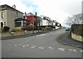
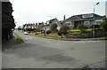
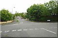
2
Braeside Avenue, Milngavie
Looking south.
Image: © Richard Sutcliffe
Taken: 14 Apr 2020
0.06 miles
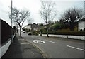
4
Braefoot Avenue, Milngavie
Looking south from Nethermains Road.
Image: © Richard Sutcliffe
Taken: 17 Jun 2020
0.07 miles

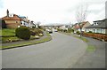
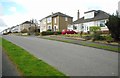
6
Drumlin Drive, Milngavie
Looking south from the junction with Nethermains Road.
Image: © Richard Sutcliffe
Taken: 14 Apr 2020
0.07 miles
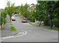
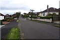
8
Braeside Avenue, Milngavie
Looking north from the junction with Nethermains Road.
Image: © Richard Sutcliffe
Taken: 14 Apr 2020
0.09 miles
9
Braeside Avenue, Milngavie
Approaching Nethermains Road.
Image: © Richard Sutcliffe
Taken: 23 Aug 2024
0.09 miles
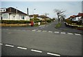
10
Junction of Braefoot Avenue and Nethermains Road
Image: © Richard Sutcliffe
Taken: 17 Jun 2020
0.10 miles