IMAGES TAKEN NEAR TO
Drumlin Drive, GLASGOW, G62 6NF
Introduction
This page details the photographs taken nearby to Drumlin Drive, G62 6NF by members of the Geograph project.
The Geograph project started in 2005 with the aim of publishing, organising and preserving representative images for every square kilometre of Great Britain, Ireland and the Isle of Man.

There are currently over 7.5m images from over14,400 individuals and you can help contribute to the project by visiting https://www.geograph.org.uk
Image Map
Images are licensed for reuse under creativecommons.org/licenses/by-sa/2.0
Notes
- Clicking on the map will re-center to the selected point.
- The higher the marker number, the further away the image location is from the centre of the postcode.
Image Listing (152 Images Found)
Images are licensed for reuse under creativecommons.org/licenses/by-sa/2.0
Image
Details
Distance
2
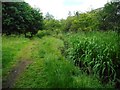
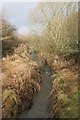
Path beside the Craigdhu Burn
The 'official' surfaced path through the Craigdhu Wedge is about 40 metres to the west. This is a muddy 'desire line' path which follows the burn. The plants beside the burn on the right are yellow flag (iris).
Image: © Richard Sutcliffe
Taken: 30 Jun 2020
0.08 miles
3
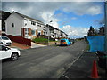
Galbraith Drive, Milngavie
Looking east. The fence and blue netting is the edge of where Scottish Water are undertaking some major sewage works.
Image: © Richard Sutcliffe
Taken: 1 Apr 2017
0.08 miles
4
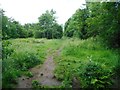
Path beside the Craigdhu Burn
The 'official' surfaced path through the Craigdhu Wedge is about 40 metres to the west. This is a muddy 'desire line' path which follows the burn. The burn itself is hidden by the vegetation growing beside it on the right.
Image: © Richard Sutcliffe
Taken: 30 Jun 2020
0.09 miles
5

The Craigdhu Wedge
A couple are walking their dog along the path on the left.
Image: © Richard Sutcliffe
Taken: 21 Jan 2018
0.09 miles
6
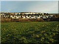
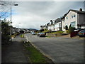
Houses, Milngavie
The houses are on Drumlin Drive and Galbraith Drive in Milngavie. The trees and scrub in the middle mark the Craigdhu Wedge, which follows the Craigdhu Burn. The burn is the boundary between Milngavie and Bearsden at this point.
Image: © Richard Sutcliffe
Taken: 30 Dec 2020
0.09 miles
7
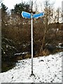
Fingerpost, Craigdhu Wedge
Kilmardinny Loch 10 min
Prestonfield 10 min
Stockiemuir Road 20 min
Allander Leisure Centre 10 min
The other direction is to Galbraith Drive.
Image: © Richard Sutcliffe
Taken: 7 Jan 2022
0.10 miles
8
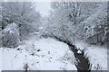
The Craigdhu Burn
Looking from the footbridge [http://www.geograph.org.uk/photo/5639968].
Image: © Richard Sutcliffe
Taken: 1 Jan 2018
0.10 miles
9
The Craigdhu Burn
Seen from the footbridge over the burn.
Image: © Richard Sutcliffe
Taken: 21 Jan 2018
0.10 miles
10
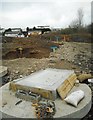
Construction of new waste water pumping station
Work on the relocation of a pumping station from Seafield Avenue in Bearsden to Galbraith Drive in Milngavie. The work will deliver environmental improvements for the Craigdhu Burn (behind the photographer).
Image: © Richard Sutcliffe
Taken: 1 Apr 2017
0.10 miles