IMAGES TAKEN NEAR TO
Glasgow Road, GLASGOW, G62 6HY
Introduction
This page details the photographs taken nearby to Glasgow Road, G62 6HY by members of the Geograph project.
The Geograph project started in 2005 with the aim of publishing, organising and preserving representative images for every square kilometre of Great Britain, Ireland and the Isle of Man.

There are currently over 7.5m images from over14,400 individuals and you can help contribute to the project by visiting https://www.geograph.org.uk
Image Map
Images are licensed for reuse under creativecommons.org/licenses/by-sa/2.0
Notes
- Clicking on the map will re-center to the selected point.
- The higher the marker number, the further away the image location is from the centre of the postcode.
Image Listing (562 Images Found)
Images are licensed for reuse under creativecommons.org/licenses/by-sa/2.0
Image
Details
Distance
1
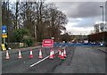
Road closed
On 24 January 2023 a major water main, carrying water from Mugdock Reservoir to Glasgow burst at the junction of the A81 (Glasgow Road) and the A809 (Auchenhowie Road), causing major flooding in the area and affecting the supplies of around 100,000 properties in Glasgow and East Dunbartonshire. Scottish Water later said a 3ft (91cm) main had ruptured. This is the scene the following day, with the roads around the junction closed to traffic. In the distance Scottish Water personnel are assessing what has happened and what needs to be done. It appears it will take somewhere between 10 and 14 days to repair the pipes and reinstate the road.
Image: © Richard Sutcliffe
Taken: 25 Jan 2023
0.01 miles
2
Electricity substation
Scottish Power Glasgow Road 53 substation, beside the A81.
Image: © Richard Sutcliffe
Taken: 26 May 2021
0.02 miles
3
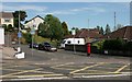
Dougalston Gardens
Junction with the A81, Glasgow Road. Dougalston Gardens North is to the left, Dougalston Gardens South to the right.
The pillarbox is postbox number G62 618D.
Image: © Richard Sutcliffe
Taken: 20 May 2020
0.03 miles
4
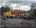
Assessing the job
Scottish Water personnel looking down into the hole caused by a burst water main.
On 24 January 2023 a major water main, carrying water from Mugdock Reservoir to Glasgow burst at the junction of the A81 (Glasgow Road) and the A809 (Auchenhowie Road), causing major flooding in the area and affecting the supplies of around 100,000 properties in Glasgow and East Dunbartonshire. Scottish Water later said a 3ft (91cm) main had ruptured. Part of this ruptured pipe (which has been removed from the ground) can be seen on the right of the photograph behind the fence.
Image: © Richard Sutcliffe
Taken: 25 Jan 2023
0.05 miles
5
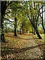
Leaves on the path
A path along the edge of Lennox Park with fallen leaves from the trees above.
Image: © Richard Sutcliffe
Taken: 26 Oct 2022
0.06 miles
6
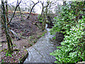
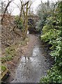
Allander Water
Looking north to the railway bridge from Glasgow Road.
Image: © Thomas Nugent
Taken: 4 Jan 2018
0.06 miles
7
Allander Water
Looking north to the railway bridge from Glasgow Road.
Image: © Thomas Nugent
Taken: 4 Jan 2018
0.06 miles
8
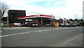
Esso Petrol Station
This petrol station on the A81, Glasgow Road was for many years a BP garage, but is now Esso.
Image: © Richard Sutcliffe
Taken: 30 Mar 2020
0.06 miles
9
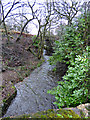
Bridge over the Allander Water
The bridge carries the railway line to Milngavie over the river.
Image: © Richard Sutcliffe
Taken: 30 Mar 2020
0.06 miles
10
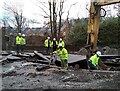
Assessing the job
Scottish Water personnel looking down into the hole caused by a burst water main.
On 24 January 2023 a major water main, carrying water from Mugdock Reservoir to Glasgow burst at the junction of the A81 (Glasgow Road) and the A809 (Auchenhowie Road), causing major flooding in the area and affecting the supplies of around 100,000 properties in Glasgow and East Dunbartonshire. Scottish Water later said a 3ft (91cm) main had ruptured. Most of the damage to the roadway here was caused by the water from the burst pipe, rather than the digger.
To further complicate the issue, it appears that there are major power cables running close to the pipe here. The man in the centre is using Catscan instrument to locate these in the hole.
Image: © Richard Sutcliffe
Taken: 25 Jan 2023
0.06 miles