IMAGES TAKEN NEAR TO
Milngavie, GLASGOW, G62 6HB
Introduction
This page details the photographs taken nearby to G62 6HB by members of the Geograph project.
The Geograph project started in 2005 with the aim of publishing, organising and preserving representative images for every square kilometre of Great Britain, Ireland and the Isle of Man.

There are currently over 7.5m images from over14,400 individuals and you can help contribute to the project by visiting https://www.geograph.org.uk
Image Map
Images are licensed for reuse under creativecommons.org/licenses/by-sa/2.0
Notes
- Clicking on the map will re-center to the selected point.
- The higher the marker number, the further away the image location is from the centre of the postcode.
Image Listing (80 Images Found)
Images are licensed for reuse under creativecommons.org/licenses/by-sa/2.0
Image
Details
Distance
1
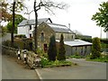
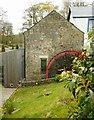
Baldernock Mill
Category C listed, mid-19th century sawmill beside the Craigmaddie Burn, now a house.
Image: © Richard Sutcliffe
Taken: 28 Apr 2020
0.01 miles
2

Baldernock Mill
Category C listed, mid-19th century sawmill beside the Craigmaddie Burn, now a house. The burn fed a mill dam upstream and water was led to the water wheel by a lade before rejoining the burn below the mill.
Image: © Richard Sutcliffe
Taken: 28 Apr 2020
0.01 miles
3
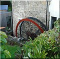
Water wheel, Baldernock Mill
The suspended pitch-back wheel is about 20ft in diameter. The wheel appears to be undergoing restoration. It has been stripped back to its frames and the steel buckets have been removed since last photographed in April 2020.
The mid-19th century sawmill is Category C listed.
Image: © Richard Sutcliffe
Taken: 5 Oct 2020
0.01 miles
4
Baldernock Mill
Category C listed, mid-19th century sawmill. The suspended pitch-back wheel is about 20ft in diameter. The wheel appears to be undergoing restoration Image It has been stripped back to its frames and the steel buckets have been removed since last photographed in April 2020.
The image was taken to replicate the first submitted for this square in 2005 Image
Image: © Richard Sutcliffe
Taken: 5 Oct 2020
0.01 miles
5
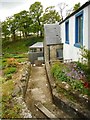
Mill lade, Baldernock Mill
The now disused lade leads to the pitch-back wheel Image, the top of which is just visible. The lade was fed from a mill dam upstream, and the water would then rejoin the Craigmaddie Burn just below the wheel.
Image: © Richard Sutcliffe
Taken: 28 Apr 2020
0.01 miles
6
Baldernock Mill
Part of the Category C listed, mid-19th century sawmill. The restored suspended pitch-back wheel is about 20ft in diameter. The wooden facing on the recent extension on the left has mellowed a bit since Image was taken five years earlier.
Image: © Richard Sutcliffe
Taken: 28 Apr 2020
0.01 miles
7
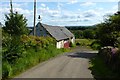
Baldernock Saw Mill
Restored mill wheel. Rest of the property is an impressive private dwelling plus outbuildings. See RCHAMS report http://canmore.org.uk/site/123036/baldernock-mill
Image: © Robert Murray
Taken: 15 Jul 2015
0.01 miles
8
![Baldernock; Building at Risk [2]](https://s0.geograph.org.uk/geophotos/04/57/25/4572544_56a57371_120x120.jpg)
Baldernock; Building at Risk [2]
Canmore http://canmore.org.uk/site/123036/baldernock-mill lists this an outbuilding and says of it; "Single storey stone built outbuilding with pitched slated roof over. S gable has doocot incorporated with 3 flightholes and a flight ledge. Large sliding door and single doorway face the road to W. More recent outbuilding abuts to the E. Elaborate weathervane with goose on N gable."
It is listed on the BARR (Building at Risk Register) website.
Image: © Robert Murray
Taken: 15 Jul 2015
0.02 miles
9
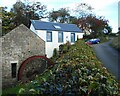
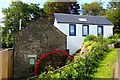
House in Baldernock
In a lovely and quaint setting.
Image: © Stephen Sweeney
Taken: 15 Jul 2009
0.02 miles
10
Baldernock; Building at Risk
Canmore lists this an outbuilding and says of it; "Single storey stone built outbuilding with pitched slated roof over. S gable has doocot incorporated with 3 flightholes and a flight ledge. Large sliding door and single doorway face the road to W. More recent outbuilding abuts to the E. Elaborate weathervane with goose on N gable."
It is listed on the BARR website.
Image: © Robert Murray
Taken: 15 Jul 2015
0.02 miles