IMAGES TAKEN NEAR TO
Barnellan, GLASGOW, G62 6EZ
Introduction
This page details the photographs taken nearby to Barnellan, G62 6EZ by members of the Geograph project.
The Geograph project started in 2005 with the aim of publishing, organising and preserving representative images for every square kilometre of Great Britain, Ireland and the Isle of Man.

There are currently over 7.5m images from over14,400 individuals and you can help contribute to the project by visiting https://www.geograph.org.uk
Image Map
Images are licensed for reuse under creativecommons.org/licenses/by-sa/2.0
Notes
- Clicking on the map will re-center to the selected point.
- The higher the marker number, the further away the image location is from the centre of the postcode.
Image Listing (7 Images Found)
Images are licensed for reuse under creativecommons.org/licenses/by-sa/2.0
Image
Details
Distance
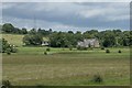
1
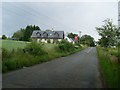
Barnellan
Small hamlet on Craigmaddie Road, north of Bardowie.
Image: © Stephen Sweeney
Taken: 15 Jul 2009
0.02 miles
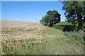
3
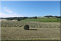
A round bale, Barnellan
It's green so it will be wrapped for silage.
Image: © Richard Webb
Taken: 17 Aug 2016
0.10 miles
4
Boghall House
Large mansion house by Craigmaddie Road, Boghall.
Image: © Stephen Sweeney
Taken: 15 Jul 2009
0.12 miles
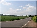
5

Wet field, Barnellan
In drumlin country between Bearsden and Kirkintilloch.
Image: © Richard Webb
Taken: 19 Jan 2014
0.13 miles
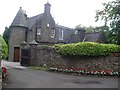
7
Boghall
A Category B listed, 17th century baronial style detached country residence built in 1907 by T. Andrew Millar of Glasgow.
Image: © Richard Sutcliffe
Taken: 2 Jul 2016
0.16 miles