IMAGES TAKEN NEAR TO
Craigdhu Avenue, GLASGOW, G62 6DX
Introduction
This page details the photographs taken nearby to Craigdhu Avenue, G62 6DX by members of the Geograph project.
The Geograph project started in 2005 with the aim of publishing, organising and preserving representative images for every square kilometre of Great Britain, Ireland and the Isle of Man.

There are currently over 7.5m images from over14,400 individuals and you can help contribute to the project by visiting https://www.geograph.org.uk
Image Map
Images are licensed for reuse under creativecommons.org/licenses/by-sa/2.0
Notes
- Clicking on the map will re-center to the selected point.
- The higher the marker number, the further away the image location is from the centre of the postcode.
Image Listing (136 Images Found)
Images are licensed for reuse under creativecommons.org/licenses/by-sa/2.0
Image
Details
Distance
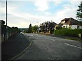
1
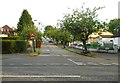
Craigdhu Avenue, Milngavie
Seen from Craigdhu Road.
Image: © Richard Sutcliffe
Taken: 17 Jun 2020
0.03 miles
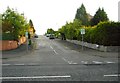
2
Craigdhu Avenue, Milngavie
Seen from Burnbrae Avenue.
Image: © Richard Sutcliffe
Taken: 17 Jun 2020
0.03 miles
3

Burnbrae Avenue, Milngavie
Looking east.
Image: © Richard Sutcliffe
Taken: 17 Jun 2020
0.05 miles
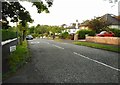
4
Crossburn Avenue, Milngavie
Seen from Craigdhu Road.
Image: © Richard Sutcliffe
Taken: 17 Jun 2020
0.05 miles
5
Lord Provost's lamppost, Burnbrae Avenue
In the past it was traditional in Scotland for the Lord Provost (whose role is similar to that of a mayor) of a town to have a special lamppost erected outside his or her house. This one (painted blue) Image is on Burnbrae Avenue.
Image: © Richard Sutcliffe
Taken: 17 Jun 2020
0.05 miles
6
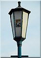
Provost's lamppost (detail)
A close up of the lamppost on Burnbrae Avenue Image Provost lamps are special decorative street lights found in some Scottish towns, used to denote the residence of the Provost, a local official equivalent to a mayor. The coat of arms is that of Bearsden and Milngavie District Council, which ceased to exist in 1996 following local government reorganisation.
Image: © Richard Sutcliffe
Taken: 17 Jun 2020
0.05 miles
7
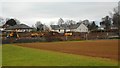
Site of former primary school
The site of the former St Joseph's Primary School https://www.geograph.org.uk/photo/6014097. The school closed in June 2018 and pupils and staff moved to the newly built St. Nicholas’ Primary the following August. The buildings lay empty for a year until demolition began in August 2019, which now appears to be almost complete. There are plans to build a new nursery for up to 90 children on the site.
Image: © Richard Sutcliffe
Taken: 3 Dec 2019
0.05 miles
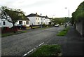
8
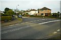
Junction of Drumcarn Drive and Braehead Avenue, Milngavie
Image: © Richard Sutcliffe
Taken: 17 Jun 2020
0.06 miles
9
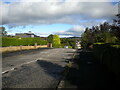
Crossburn Avenue, Milngavie
Looking towards Craigdhu Road from its junction with Braehead Avenue.
Image: © Richard Vince
Taken: 12 Sep 2022
0.07 miles
10
Crossburn Avenue, Milngavie
Seen from Burnbrae Avenue, looking north.
Image: © Richard Sutcliffe
Taken: 17 Jun 2020
0.07 miles