IMAGES TAKEN NEAR TO
Main Street, GLASGOW, G62 6BU
Introduction
This page details the photographs taken nearby to Main Street, G62 6BU by members of the Geograph project.
The Geograph project started in 2005 with the aim of publishing, organising and preserving representative images for every square kilometre of Great Britain, Ireland and the Isle of Man.

There are currently over 7.5m images from over14,400 individuals and you can help contribute to the project by visiting https://www.geograph.org.uk
Image Map
Images are licensed for reuse under creativecommons.org/licenses/by-sa/2.0
Notes
- Clicking on the map will re-center to the selected point.
- The higher the marker number, the further away the image location is from the centre of the postcode.
Image Listing (996 Images Found)
Images are licensed for reuse under creativecommons.org/licenses/by-sa/2.0
Image
Details
Distance
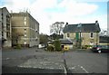
1
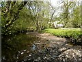
Allander Water and Gavin's Mill
After a long dry spell, the Allander Water is running low through Lennox Park. The mill Image is Category B listed.
Image: © Richard Sutcliffe
Taken: 28 Apr 2021
0.01 miles
2
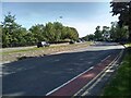
Woodburn Way
The B8030, Woodburn Way bypasses the centre of Milngavie, which is pedestrianised.
Image: © Richard Sutcliffe
Taken: 29 May 2023
0.01 miles
3
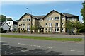
Fairview Court
Flats on Woodburn Way, Milngavie.
Image: © Richard Sutcliffe
Taken: 2 Jun 2021
0.01 miles
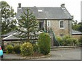
4
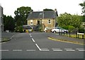
Ashfield Road
The building is Ashfield House, home to Ashfield Medical Practice.
Image: © Richard Sutcliffe
Taken: 17 Jun 2020
0.02 miles
5
Ashfield Road
On the left is the telephone exchange, built in the 1970s. The building on the right is the Ashfield Medical Practice, seen from the back.
Image: © Richard Sutcliffe
Taken: 14 Apr 2017
0.02 miles
6
Ashfield Medical Practice
Seen from the back, on Ashfield Road.
Image: © Richard Sutcliffe
Taken: 20 Aug 2020
0.02 miles
7
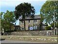
Ashfield Medical Practice
With a monkey puzzle tree in front.
Image: © Richard Sutcliffe
Taken: 2 Jun 2021
0.02 miles
8
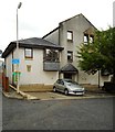
Flats, Ashfield Road, Milngavie
The flats occupy the site of the former telephone exchange. It was replaced by a larger modern building close by in the 1970s. The flats incorporate architectural elements of the old building, including a keystone dated 1936 with the cipher of Edward VIII Image
Image: © Richard Sutcliffe
Taken: 20 Aug 2020
0.03 miles
9
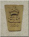
Architectural detail
This keystone, dated 1936 with the cipher of Edward VIII, is from the former telephone exchange which used to stand on this site, which was replaced by a larger modern building close by in the 1970s. The flats which now occupy the site Image incorporate architectural elements from the old building, including the keystone.
Image: © Richard Sutcliffe
Taken: 20 Aug 2020
0.03 miles
10
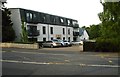
Flats on Park Road, Milngavie
Before these flats were built in 2017/18, the site was occupied by a vehicle accident repair centre.
Image: © Richard Sutcliffe
Taken: 17 Jun 2020
0.03 miles