IMAGES TAKEN NEAR TO
South Glassford Street, GLASGOW, G62 6AT
Introduction
This page details the photographs taken nearby to South Glassford Street, G62 6AT by members of the Geograph project.
The Geograph project started in 2005 with the aim of publishing, organising and preserving representative images for every square kilometre of Great Britain, Ireland and the Isle of Man.

There are currently over 7.5m images from over14,400 individuals and you can help contribute to the project by visiting https://www.geograph.org.uk
Image Map
Images are licensed for reuse under creativecommons.org/licenses/by-sa/2.0
Notes
- Clicking on the map will re-center to the selected point.
- The higher the marker number, the further away the image location is from the centre of the postcode.
Image Listing (453 Images Found)
Images are licensed for reuse under creativecommons.org/licenses/by-sa/2.0
Image
Details
Distance
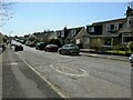
2
Baldernock Road
Looking down the hill towards Milngavie.
Image: © Richard Sutcliffe
Taken: 28 Apr 2020
0.04 miles
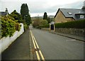
3
South Glassford Street, Milngavie
Looking south.
Image: © Richard Sutcliffe
Taken: 28 Apr 2020
0.04 miles
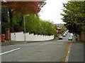
4

South Glassford Street
Looking south from Baldernock Road.
Image: © Thomas Nugent
Taken: 4 Jan 2018
0.05 miles
5
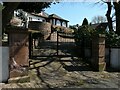
Gates to 'The Meadows'
On South Glassford Street.
Image: © Richard Sutcliffe
Taken: 21 Apr 2021
0.06 miles
6
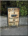
Old milepost, Glasgow Road
The Category C listed cast-iron milepost dates from 1861 http://portal.historicenvironment.scot/designation/LB48608. It reads:
GLASGOW
ROYAL EXCHANGE
7
BALFRON
12
ABERFOIL
19
'Aberfoil' is the old spelling for Aberfoyle.
There is a crack down the centre of the post.
Image: © Richard Sutcliffe
Taken: 30 Mar 2020
0.07 miles
7
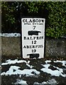
Old milestone, Glasgow Road
The milestone has recently been repainted by members of Milngavie and Bearsden Men’s Shed. For an earlier view with more information see Image
Image: © Richard Sutcliffe
Taken: 7 Jan 2021
0.07 miles
8

Old Milepost by the A81, Glasgow Road, New Kilpatrick
Glasgow curved cast iron plate by the A81, in parish of New Kilpatrick (East Dunbartonshire), Glasgow Road, Milngavie, between Nos. 13 and 15 (Auchencairn), set in wall. Cracked vertically down the centre.
Inscription reads:-
GLASGOW
ROYAL EXCHANGE
7
{hand->}
BALFRON
12
ABERFOIL
19
{<-hand}
HES Grade C(S) listed.
Reference: LB48608 http://portal.historicenvironment.scot/designation/LB48608
Surveyed
Milestone Society National ID: ED_GWAF07
Image: © Milestone Society
Taken: Unknown
0.07 miles
9
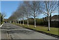
Birch trees, Dougalston Avenue
I think these are Betula utilis jacquemontii. With their pure white bark, they form an impressive line along the side of the road.
Image: © Richard Sutcliffe
Taken: 21 Apr 2021
0.07 miles
10
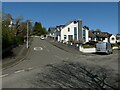
Looking up Briarwell Road
From the junction with Dougalston Avenue.
Image: © Richard Sutcliffe
Taken: 21 Apr 2021
0.07 miles