IMAGES TAKEN NEAR TO
Lochnagar Drive, GLASGOW, G61 4RP
Introduction
This page details the photographs taken nearby to Lochnagar Drive, G61 4RP by members of the Geograph project.
The Geograph project started in 2005 with the aim of publishing, organising and preserving representative images for every square kilometre of Great Britain, Ireland and the Isle of Man.

There are currently over 7.5m images from over14,400 individuals and you can help contribute to the project by visiting https://www.geograph.org.uk
Image Map
Images are licensed for reuse under creativecommons.org/licenses/by-sa/2.0
Notes
- Clicking on the map will re-center to the selected point.
- The higher the marker number, the further away the image location is from the centre of the postcode.
Image Listing (31 Images Found)
Images are licensed for reuse under creativecommons.org/licenses/by-sa/2.0
Image
Details
Distance
1
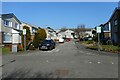
Lochnagar Drive
Off Grampian Way.
Image: © Richard Sutcliffe
Taken: 27 Mar 2022
0.02 miles
2
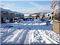
Lochnagar Drive in winter
Taken on 30th November 2010. Little did we know then how long the snow would be with us.
Image: © Gordon Carruthers
Taken: 30 Nov 2010
0.03 miles
3
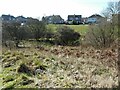
Houses on Grampian Way
They overlook an area of cut grass, together with trees and scrub around the Manse Burn.
Image: © Richard Sutcliffe
Taken: 27 Mar 2022
0.04 miles
4
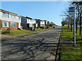
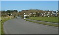
Grampian Way
The main street through South Baljaffray, which follows a roughly oval route through the district.
Image: © Richard Sutcliffe
Taken: 27 Mar 2022
0.04 miles
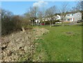
5
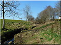
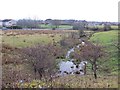
The Manse Burn
The burn runs through Baljaffray, between Grampian Way to the north; and Ochil Road and Cruachan Road to the south.
Image: © Richard Sutcliffe
Taken: 27 Mar 2022
0.07 miles
6
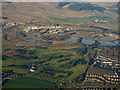
Windyhill Golf Club from the air
Overshadowed in this view by Tarmac's Douglasmuir quarry. Baljaffray Road is in the foreground.
Image: © Thomas Nugent
Taken: 4 Dec 2016
0.08 miles
7
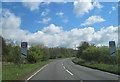
Entrance to Windyhill Golf Course from B8050
Image: © John Firth
Taken: 12 May 2012
0.09 miles
8
Bus shelter on Ledi Drive
Looking towards the junction with Grampian Way.
Image: © Richard Sutcliffe
Taken: 27 Mar 2022
0.10 miles
9
Area beside the Manse Burn
The Manse Burn runs through Baljaffray, between Grampian Way (behind the photographer); and Ochil Road and Cruachan Road (in the distance).
Image: © Richard Sutcliffe
Taken: 27 Mar 2022
0.10 miles
10
Manse Burn, Baljaffray
Some rather wet urban fringe farmland.
Image: © Richard Webb
Taken: 19 Jan 2014
0.10 miles