IMAGES TAKEN NEAR TO
Duntocher Road, GLASGOW, G61 4QG
Introduction
This page details the photographs taken nearby to Duntocher Road, G61 4QG by members of the Geograph project.
The Geograph project started in 2005 with the aim of publishing, organising and preserving representative images for every square kilometre of Great Britain, Ireland and the Isle of Man.

There are currently over 7.5m images from over14,400 individuals and you can help contribute to the project by visiting https://www.geograph.org.uk
Image Map
Images are licensed for reuse under creativecommons.org/licenses/by-sa/2.0
Notes
- Clicking on the map will re-center to the selected point.
- The higher the marker number, the further away the image location is from the centre of the postcode.
Image Listing (17 Images Found)
Images are licensed for reuse under creativecommons.org/licenses/by-sa/2.0
Image
Details
Distance
1
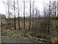
Young woodland, Garscadden
Beside an old road alignment.
Image: © Richard Webb
Taken: 19 Jan 2014
0.04 miles
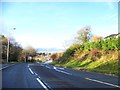
2
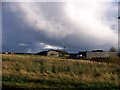
Looking up towards Langfaulds from Baljaffray Road
Image: © Elliott Simpson
Taken: 9 Nov 2013
0.05 miles
4
Garscadden
From the signs, it looks as if there was a recycling centre here, now closed.
Image: © Richard Webb
Taken: 19 Jan 2014
0.07 miles
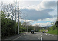
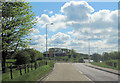
5
A810 approaching junction with A8050
Image: © Elliott Simpson
Taken: 9 Nov 2013
0.09 miles
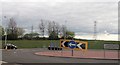
7
Roundabout at junction of A810 and B8050
A810 looking east
Image: © John Firth
Taken: 12 May 2012
0.10 miles
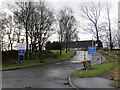
8
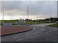
Langfaulds Roundabout
New alignment where the B8050 Baljaffray Road meets the A810.
Image: © Richard Webb
Taken: 19 Jan 2014
0.11 miles
9
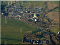
Electrical Sub Station from the air
On the A810 Duntcher Road.
Image: © Thomas Nugent
Taken: 4 Dec 2016
0.13 miles
10
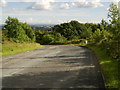
Peel Glen Road
From Bearsden down to Drumchapel.
Image: © Stephen Sweeney
Taken: 22 Jul 2007
0.15 miles