IMAGES TAKEN NEAR TO
Collylinn Road, GLASGOW, G61 4PN
Introduction
This page details the photographs taken nearby to Collylinn Road, G61 4PN by members of the Geograph project.
The Geograph project started in 2005 with the aim of publishing, organising and preserving representative images for every square kilometre of Great Britain, Ireland and the Isle of Man.

There are currently over 7.5m images from over14,400 individuals and you can help contribute to the project by visiting https://www.geograph.org.uk
Image Map
Images are licensed for reuse under creativecommons.org/licenses/by-sa/2.0
Notes
- Clicking on the map will re-center to the selected point.
- The higher the marker number, the further away the image location is from the centre of the postcode.
Image Listing (378 Images Found)
Images are licensed for reuse under creativecommons.org/licenses/by-sa/2.0
Image
Details
Distance
1
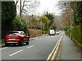
Collylinn Road
Looking towards Drymen Road.
Image: © Richard Sutcliffe
Taken: 12 Apr 2022
0.03 miles
2
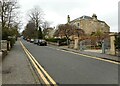
Collylinn Road
There are some large villas on Collylinn Road.
Image: © Richard Sutcliffe
Taken: 12 Apr 2022
0.04 miles
3
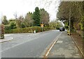
Whitehill Road
At the junction with Collylinn Road.
Image: © Richard Sutcliffe
Taken: 12 Apr 2022
0.09 miles
4
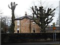
Severe pruning
The trees in this garden have been having some serious attention.
Image: © Richard Sutcliffe
Taken: 21 Dec 2019
0.10 miles
5
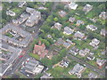
Cross roads, Bearsden
An aerial view of the A809 [Drymen Road, lower left to top centre]/A808 [Roman Road, to the left]/Thorn Road [to the right] junction. The central church is disused, and to let [Google Earth, August 2014, as a 'unique restaurant opportunity']; adjacent to it is Bearsden Hall; the church at the top is Bearsden Cross Parish Church; the large building at upper left is Bearsden Primary School.
Image: © M J Richardson
Taken: 5 Aug 2015
0.10 miles
6

Window, Bearsden North Church
The cross- and quatrefoil-traceried circular window in the west-facing gable of the church. Originally built for the Free Church in Bearsden and opened in 1889, it became the Church of Scotland North Parish Church in 1929. Services moved to the new Bearsden Cross Parish Church following the formal union of Bearsden South and Bearsden North Churches in 2006.
It is Category B listed http://portal.historicenvironment.scot/designation/LB48595.
Image: © Richard Sutcliffe
Taken: 15 Feb 2022
0.10 miles
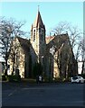
7
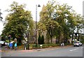
Bearsden North Church
Category B listed church http://portal.historicenvironment.scot/designation/LB48595, dating from 1887-9. Originally built as Bearsden Free Church, it became the North Parish Church in 1929. Services moved to the new Bearsden Cross Parish Church following the formal union of Bearsden South and Bearsden North Churches in 2006.
Image: © Richard Sutcliffe
Taken: 14 Sep 2019
0.10 miles
8
Bearsden North Church
Category B listed church http://portal.historicenvironment.scot/designation/LB48595, dating from 1887-9. Originally built as Bearsden Free Church, it became the North Parish Church in 1929. Services moved to the new Bearsden Cross Parish Church following the formal union of Bearsden South and Bearsden North Churches in 2006.
Image: © Richard Sutcliffe
Taken: 14 Sep 2019
0.10 miles
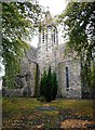
9
Bearsden North Church
Category B listed church http://portal.historicenvironment.scot/designation/LB48595, dating from 1887-9. Originally built as Bearsden Free Church, it became the North Parish Church in 1929. Services moved to the new Bearsden Cross Parish Church following the formal union of Bearsden South and Bearsden North Churches in 2006.
Image: © Richard Sutcliffe
Taken: 21 Nov 2021
0.10 miles
10
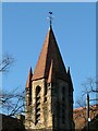
Spire, Bearsden North Church
Category B listed church http://portal.historicenvironment.scot/designation/LB48595, dating from 1887-9. Originally built as Bearsden Free Church, it became the North Parish Church in 1929.
Image: © Richard Sutcliffe
Taken: 21 Nov 2021
0.10 miles