IMAGES TAKEN NEAR TO
Chesters Road, GLASGOW, G61 4AQ
Introduction
This page details the photographs taken nearby to Chesters Road, G61 4AQ by members of the Geograph project.
The Geograph project started in 2005 with the aim of publishing, organising and preserving representative images for every square kilometre of Great Britain, Ireland and the Isle of Man.

There are currently over 7.5m images from over14,400 individuals and you can help contribute to the project by visiting https://www.geograph.org.uk
Image Map
Images are licensed for reuse under creativecommons.org/licenses/by-sa/2.0
Notes
- Clicking on the map will re-center to the selected point.
- The higher the marker number, the further away the image location is from the centre of the postcode.
Image Listing (42 Images Found)
Images are licensed for reuse under creativecommons.org/licenses/by-sa/2.0
Image
Details
Distance
1
House on Chesters Road
Whitehill Lane leads off to the left.
Image: © Richard Sutcliffe
Taken: 12 Apr 2022
0.11 miles
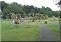
2
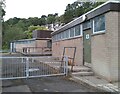
Sports pavilion, Colquhoun Park
Just off Station Road.
Image: © Richard Sutcliffe
Taken: 7 Aug 2021
0.11 miles
3
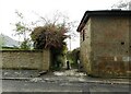
Whitehill Lane
Path leading from here on Chesters Road to Whitehill Road.
Image: © Richard Sutcliffe
Taken: 12 Apr 2022
0.12 miles
4

The High School of Glasgow - Junior School
School buildings at 27 Ledcameroch Road.
Image: © Richard Sutcliffe
Taken: 22 Apr 2018
0.13 miles
5
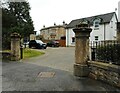
Chesters House
The house on the left was originally known as Ledcameroch West when built (probably about 1873). It was renamed Chesters in 1880 when it came under new ownership. It was gifted to the Royal College of Science and Technology in 1952 and became a residential management college. It was purchased by the Roman Catholic Diocese in 1984 and became Chesters College, later Scotus College, the National Seminary for Scotland in 1993. Scotus College Chapel was built adjacent to the house (See Canmore https://canmore.org.uk/site/297159/bearsden-chesters-road-scotus-college-chapel. The college closed in 2009, due to the very low number of students studying for the preisthood. In 2013 the chapel and other buildings were demolished and the site converted into housing. The house is Category C listed http://portal.historicenvironment.scot/designation/LB50878.
Image: © Richard Sutcliffe
Taken: 12 Apr 2022
0.13 miles
6

The High School of Glasgow - Junior School
School buildings at 27 Ledcameroch Road.
Image: © Richard Sutcliffe
Taken: 22 Apr 2018
0.13 miles
7
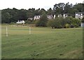
Football pitch, Colquhoun Park
The houses are on Station Road.
Image: © Richard Sutcliffe
Taken: 7 Aug 2021
0.14 miles
8
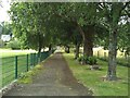
Path, Colqhoun Park
The path runs from Conan Avenue to the sports pavilion beside Station Road. On the left are playing fields, to the right of the trees is the wetland area developed as a Flood Alleviation Scheme.
Image: © Richard Sutcliffe
Taken: 7 Aug 2021
0.14 miles
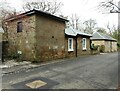
10
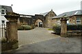
Chesters Mews
The archway and former stable block of Chesters House, dating from about 1873. The house was purchased by the Roman Catholic Diocese in 1984 and became Chesters College, later Scotus College, the National Seminary for Scotland from 1993 to 2009. In 2013 the site was converted into housing. The house, former stables and gate piers are Category C listed http://portal.historicenvironment.scot/designation/LB50878.
Image: © Richard Sutcliffe
Taken: 12 Apr 2022
0.15 miles