IMAGES TAKEN NEAR TO
Kilmardinny Avenue, GLASGOW, G61 3NL
Introduction
This page details the photographs taken nearby to Kilmardinny Avenue, G61 3NL by members of the Geograph project.
The Geograph project started in 2005 with the aim of publishing, organising and preserving representative images for every square kilometre of Great Britain, Ireland and the Isle of Man.

There are currently over 7.5m images from over14,400 individuals and you can help contribute to the project by visiting https://www.geograph.org.uk
Image Map
Images are licensed for reuse under creativecommons.org/licenses/by-sa/2.0
Notes
- Clicking on the map will re-center to the selected point.
- The higher the marker number, the further away the image location is from the centre of the postcode.
Image Listing (233 Images Found)
Images are licensed for reuse under creativecommons.org/licenses/by-sa/2.0
Image
Details
Distance
1
Kilmardinny Lodge
Former Kilmardinny Estate lodge house at the junction of the A81 Milngavie Road and Kilmardinny Avenue.
Image: © Richard Sutcliffe
Taken: 20 Jun 2015
0.01 miles
2
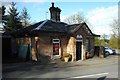
Kilmardinny Lodge
A Category C listed early 19th century lodge house for Kilmardinny House, now a private residence.
Image: © Richard Sutcliffe
Taken: 24 Apr 2018
0.01 miles
3
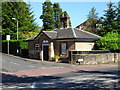
Kilmardinny Lodge
Kilmardinny Lodge a 19th century building on the junction of Kilmardinny Avenue and Milngavie Road. The lodge is Category C Listed.
Image: © Philip Halling
Taken: 27 Jun 2019
0.01 miles
4
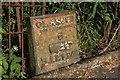
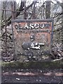
Milepost, Milngavie Road
This cast iron milepost beside Milngavie Road [http://www.geograph.org.uk/photo/4993909] is partially buried. The top says: 'GLASGOW Royal Exchange 6' (and pointing hand). The bottom says: 'BALFRON', but the rest is not visible.
Image: © Richard Sutcliffe
Taken: 9 Jun 2016
0.01 miles
5
Old Milepost by the A81, Milngavie Road, Bearsden
Glasgow curved cast iron post by the A81, in parish of New Kilpatrick (East Dunbartonshire), Milngavie Road, Bearsden, opposite Kilmardinny Avenue, at entrance to Bearsden Golf Club.
Inscription reads:-
GLASGOW
ROYAL EXCHANGE
6
{pointing hand}
BALFRON
13
Grade C(S) listed. Reference: LB48603 http://portal.historicenvironment.scot/designation/LB48603
Surveyed
Milestone Society National ID: ED_GWAF06
Image: © Milestone Society
Taken: Unknown
0.01 miles
6
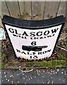
Milepost, Milngavie Road
This milestone was repainted during 2021 by members of the local 'Men's Shed' group. As a result, some of the soil has been removed, making it possible to see more of the lettering than was visible previously Image, Image It is now possible to make out the word 'ABERFOIL' (old spelling for Aberfoyle), although the mileage and direction arrow are still hidden.
Image: © Richard Sutcliffe
Taken: 12 Jan 2022
0.01 miles
7
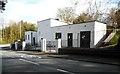
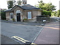
Electricity Sub-station
At the junction of Kilmardinny Avenue and Milngavie Road. The building was re-painted during 2017 and is looking quite smart.
Image: © Richard Sutcliffe
Taken: 24 Apr 2018
0.01 miles
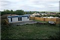
8
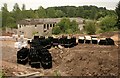
Storage area beside former Equestrian Centre
Materials for the construction of the new Robertson Homes development, stored close to the site beside the former Equestrian Centre.
Image: © Richard Sutcliffe
Taken: 10 Jul 2018
0.01 miles
9
Marketing Suite, Kilmardinny Gait
Now that the first of the new Robertson Homes properties at Kilmardinny Gait are under construction, a marketing suite has appeared.
Image: © Richard Sutcliffe
Taken: 7 Sep 2018
0.01 miles
10

Building more houses
Construction work continues building Robertson Homes at Kilmardinny. These new houses are on the site of the former Kilmardinny Equestrian Centre [https://www.geograph.org.uk/photo/5751499].
Image: © Richard Sutcliffe
Taken: 29 Apr 2019
0.01 miles