IMAGES TAKEN NEAR TO
Robert Burns Drive, GLASGOW, G61 3DD
Introduction
This page details the photographs taken nearby to Robert Burns Drive, G61 3DD by members of the Geograph project.
The Geograph project started in 2005 with the aim of publishing, organising and preserving representative images for every square kilometre of Great Britain, Ireland and the Isle of Man.

There are currently over 7.5m images from over14,400 individuals and you can help contribute to the project by visiting https://www.geograph.org.uk
Image Map
Images are licensed for reuse under creativecommons.org/licenses/by-sa/2.0
Notes
- Clicking on the map will re-center to the selected point.
- The higher the marker number, the further away the image location is from the centre of the postcode.
Image Listing (112 Images Found)
Images are licensed for reuse under creativecommons.org/licenses/by-sa/2.0
Image
Details
Distance
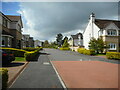
1
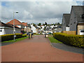
Robert Burns Drive
Residential street in Bearsden.
Image: © Richard Sutcliffe
Taken: 9 May 2023
0.01 miles
2
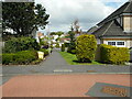
Path to Elm Walk
From Norman MacLeod Crescent.
Image: © Richard Sutcliffe
Taken: 9 May 2023
0.03 miles
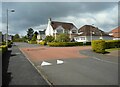
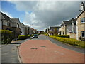
3
Norman MacLeod Crescent
Norman MacLeod was the rector (headmaster) of Bearsden Academy, which was located close by until a new school was built elsewhere. The site was used for housing and the street name reflects the history of the site.
Image: © Richard Sutcliffe
Taken: 9 May 2023
0.03 miles
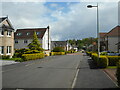
4
Road junction
Robert Burns Drive meets Norman MacLeod Crescent.
Image: © Richard Sutcliffe
Taken: 9 May 2023
0.03 miles
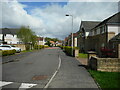
5
Norman MacLeod Crescent
Norman MacLeod was the rector (headmaster) of Bearsden Academy, which was located close by until a new school was built elsewhere. The site was used for housing and the street name reflects the history of the site.
Image: © Richard Sutcliffe
Taken: 9 May 2023
0.04 miles
6
Norman MacLeod Crescent
Norman MacLeod was the rector (headmaster) of Bearsden Academy, which was located close by until a new school was built elsewhere. The site was used for housing and the new street names reflect the history of the site.
Image: © Richard Sutcliffe
Taken: 9 May 2023
0.05 miles
7
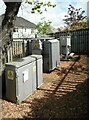
Electricity Substation
Substation 'Russell Drive 11' at the corner of Russell Drive and Norman MacLeod Crescent.
Image: © Richard Sutcliffe
Taken: 9 May 2023
0.07 miles
8
Norman MacLeod Crescent
Norman MacLeod was the rector (headmaster) of Bearsden Academy, which was located close by until a new school was built elsewhere. The site was used for housing and the street name reflects the history of the site.
Image: © Richard Sutcliffe
Taken: 9 May 2023
0.07 miles
9
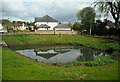
SuDS pond
Sustainable urban Drainage System pond beside Norman MacLeod Crescent. There is plenty of water in it, following recent heavy rain.
Image: © Richard Sutcliffe
Taken: 9 May 2023
0.08 miles
10
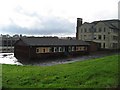
Bearsden Academy (closed)
The old Bearsden Academy. The school moved to a new site this summer (2009)(http://www.geograph.org.uk/photo/1607340). The old site is being developed for housing.
Image: © David Robertson
Taken: Unknown
0.08 miles