IMAGES TAKEN NEAR TO
St. Andrews Way, GLASGOW, G61 3AX
Introduction
This page details the photographs taken nearby to St. Andrews Way, G61 3AX by members of the Geograph project.
The Geograph project started in 2005 with the aim of publishing, organising and preserving representative images for every square kilometre of Great Britain, Ireland and the Isle of Man.

There are currently over 7.5m images from over14,400 individuals and you can help contribute to the project by visiting https://www.geograph.org.uk
Image Map (Loading...)


Getting Data...Please wait
Leaflet Map data © OpenStreetMap
Images are licensed for reuse under creativecommons.org/licenses/by-sa/2.0
Notes
- Clicking on the map will re-center to the selected point.
- The higher the marker number, the further away the image location is from the centre of the postcode.
Image Listing (29 Images Found)
Images are licensed for reuse under creativecommons.org/licenses/by-sa/2.0
Image
Details
Distance
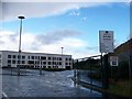
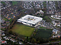
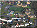
2
Bearsden Academy from the air
With part of St Andrew's Primary school on the left edge and, just beyond the academy, Buchanan Lodge and Care Home.
Image: © M J Richardson
Taken: 3 Oct 2015
0.07 miles
4
New Bearsden Academy
The New Bearsden Academy. It opened this summer (2009). The old school looks a little less splendid http://www.geograph.org.uk/photo/1607355
Image: © David Robertson
Taken: Unknown
0.12 miles
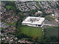
5
Bearsden Academy from the air
A game of football is in progress on the darker pitch.
Image: © Thomas Nugent
Taken: 3 Nov 2017
0.12 miles
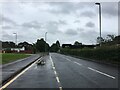
6
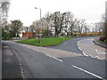
Road Junction on the A809 in Bearsden
The A809 continues to the right and leads to Drymen. The road to the left leads to Dumbarton after joining the A82.
Image: © G Laird
Taken: 26 Dec 2013
0.14 miles
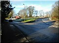
7
Beginning of Stockiemuir Road
At Drymen Road in Bearsden.
Image: © Stephen Sweeney
Taken: 2 Aug 2007
0.15 miles
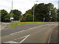
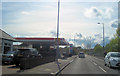
8
Road junction
The A809 Drymen Road goes to the right where it becomes Stockiemuir Road. To the left it becomes the A810 Duntocher Road.
Image: © Richard Sutcliffe
Taken: 17 Jan 2023
0.15 miles
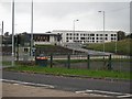
9
Bearsden from the air
The Gulf petrol station on Duntocher Road and St Nicholas' Primary School's playing fields are prominent.
Image: © Thomas Nugent
Taken: 24 Jan 2020
0.16 miles
10
Esso garage on Duntochor Road
Opposite Farm Lane
Image: © John Firth
Taken: 12 May 2012
0.16 miles