IMAGES TAKEN NEAR TO
Boclair Road, GLASGOW, G61 2TH
Introduction
This page details the photographs taken nearby to Boclair Road, G61 2TH by members of the Geograph project.
The Geograph project started in 2005 with the aim of publishing, organising and preserving representative images for every square kilometre of Great Britain, Ireland and the Isle of Man.

There are currently over 7.5m images from over14,400 individuals and you can help contribute to the project by visiting https://www.geograph.org.uk
Image Map
Images are licensed for reuse under creativecommons.org/licenses/by-sa/2.0
Notes
- Clicking on the map will re-center to the selected point.
- The higher the marker number, the further away the image location is from the centre of the postcode.
Image Listing (13 Images Found)
Images are licensed for reuse under creativecommons.org/licenses/by-sa/2.0
Image
Details
Distance
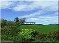
5
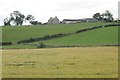
Boclair Farm
Seen from the Allander Walkway.
Image: © Richard Sutcliffe
Taken: 8 Aug 2018
0.12 miles
6
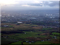
Millichen Road from the air
Dusk falls over the road and the River Kelvin. Glasgow is in the distance.
Image: © Thomas Nugent
Taken: 17 Nov 2017
0.20 miles
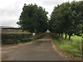
7
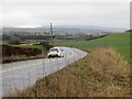
Boclair Road
B8049 near Bearsden. A twisty road with quite a bit of up and down motion too due to the drumlins.
Image: © Richard Webb
Taken: 19 Jan 2014
0.20 miles
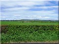
8
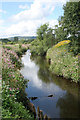
Allander Water
Seen from the Allander Walkway.
Image: © Richard Sutcliffe
Taken: 8 Aug 2018
0.22 miles
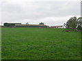
9
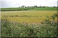
Ripening cereal crop
Looking across a cereal field towards Boclair Farm.
Image: © Richard Sutcliffe
Taken: 8 Aug 2018
0.22 miles
10

Multi-coloured cow
Most of the cattle in the field were displaying blue and orange markings.
Image: © Richard Sutcliffe
Taken: 31 Aug 2021
0.24 miles