IMAGES TAKEN NEAR TO
Kessington Square, GLASGOW, G61 2QQ
Introduction
This page details the photographs taken nearby to Kessington Square, G61 2QQ by members of the Geograph project.
The Geograph project started in 2005 with the aim of publishing, organising and preserving representative images for every square kilometre of Great Britain, Ireland and the Isle of Man.

There are currently over 7.5m images from over14,400 individuals and you can help contribute to the project by visiting https://www.geograph.org.uk
Image Map
Images are licensed for reuse under creativecommons.org/licenses/by-sa/2.0
Notes
- Clicking on the map will re-center to the selected point.
- The higher the marker number, the further away the image location is from the centre of the postcode.
Image Listing (35 Images Found)
Images are licensed for reuse under creativecommons.org/licenses/by-sa/2.0
Image
Details
Distance
1
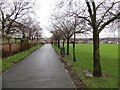
George V playing field
The path continues through the houses to Albert Drive.
Image: © Richard Webb
Taken: 19 Jan 2014
0.01 miles
2
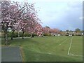
The edge of King George V Field
Looking from beside the pavilion. The trees are covered in blossom.
King George's fields are public open spaces in the United Kingdom dedicated to the memory of King George V and protected by Fields in Trust in perpetuity. See https://en.wikipedia.org/wiki/King_George%27s_Fields.
Image: © Richard Sutcliffe
Taken: 5 May 2021
0.02 miles
3
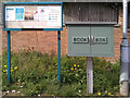
Notice board and book box
Beside the path near the entrance to King George V Park. The notice board has information relating to the park and local events, together with a copy of the Scottish Government's FACTS guidance relating to the Coronavirus (Covid-19) pandemic.
The book box is presumably a book-sharing scheme, but I didn't look inside to see.
Image: © Richard Sutcliffe
Taken: 5 May 2021
0.03 miles
4
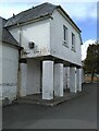
Pavilion next to the pagoda
Just to the north of the pagoda Image, overlooking King George V Field. The building was used as a Civil Defence Post during the Second World War Image
Image: © Richard Sutcliffe
Taken: 5 May 2021
0.04 miles
5
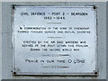
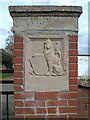
Plaque on the pavilion, King George V Park
The plaque is on one of the pillars at the entrance to the building Image
CIVIL DEFENCE – POST 2 – BEARSDEN
1939-1945.
IN COMMEMORATION OF THE BOND OF FRIENDSHIP
FORMED THROUGH SERVICE AND MUTUAL SACRIFICE.
ERECTED BY THE AIR RAID WARDENS WHO
SERVED AT THE POST WITHIN THIS PAVILION
DURING THE SECOND WORLD WAR.
PEACE IN OUR TIME, O LORD.
Image: © Richard Sutcliffe
Taken: 5 May 2021
0.04 miles
6
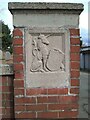
Gate pier to King George's Field
One of two brick gate piers at the entrance to King George's Field Image It bears the inscription:
GEORGE V
AD 1910-1936
Image: © Richard Sutcliffe
Taken: 5 May 2021
0.04 miles
7
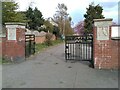
Gates to King George's Field
At the end of Borland Road. King George's fields are public open spaces in the United Kingdom dedicated to the memory of King George V and protected by Fields in Trust in perpetuity. See https://en.wikipedia.org/wiki/King_George%27s_Fields.
Image: © Richard Sutcliffe
Taken: 5 May 2021
0.04 miles
8
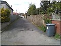
Empty lane
The lane leads from Borland Road to Kessington Road.
Image: © Richard Sutcliffe
Taken: 5 May 2021
0.04 miles
9
Gate pier to King George's Field
One of two brick gate piers at the entrance to King George's Field Image It bears the inscription:
KING GEORGE'S
FIELD
Image: © Richard Sutcliffe
Taken: 5 May 2021
0.04 miles
10
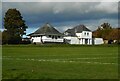
Pavilion, King George V Park
At Killermont, Bearsden.
Image: © Richard Sutcliffe
Taken: 16 Oct 2020
0.04 miles