IMAGES TAKEN NEAR TO
Afton Crescent, GLASGOW, G61 2PY
Introduction
This page details the photographs taken nearby to Afton Crescent, G61 2PY by members of the Geograph project.
The Geograph project started in 2005 with the aim of publishing, organising and preserving representative images for every square kilometre of Great Britain, Ireland and the Isle of Man.

There are currently over 7.5m images from over14,400 individuals and you can help contribute to the project by visiting https://www.geograph.org.uk
Image Map
Images are licensed for reuse under creativecommons.org/licenses/by-sa/2.0
Notes
- Clicking on the map will re-center to the selected point.
- The higher the marker number, the further away the image location is from the centre of the postcode.
Image Listing (40 Images Found)
Images are licensed for reuse under creativecommons.org/licenses/by-sa/2.0
Image
Details
Distance
1
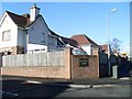
Kessington Square
Fairly recent housing development in Kessington.
Image: © Stephen Sweeney
Taken: 25 Mar 2009
0.05 miles
2
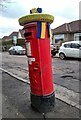
In support of Ukraine
Produced by the Killermont Crafters to show local support for the people of Ukraine, following the invasion by Russion forces.
The pillar box is on Kessington Road and is postbox number G61 916.
Image: © Richard Sutcliffe
Taken: 10 Mar 2022
0.07 miles
3

In support of Ukraine
On top of a pillar box on Kessington Road Image Produced by the Killermont Crafters to show local support for the people of Ukraine, following the invasion by Russion forces.
Image: © Richard Sutcliffe
Taken: 10 Mar 2022
0.07 miles
4
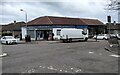
Corner shop
Murdo's Corner Shop, at the junction of Kessington Road and Rannoch Drive.
Image: © Richard Sutcliffe
Taken: 10 Mar 2022
0.08 miles
5
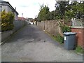
Empty lane
The lane leads from Borland Road to Kessington Road.
Image: © Richard Sutcliffe
Taken: 5 May 2021
0.08 miles
6
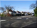
Mini roundabout, Rannoch Drive
At the junction with Kessington Road and Oronsay Crescent.
Image: © Stephen Sweeney
Taken: 25 Mar 2009
0.09 miles
7
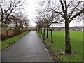
George V playing field
The path continues through the houses to Albert Drive.
Image: © Richard Webb
Taken: 19 Jan 2014
0.10 miles
8
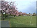
The edge of King George V Field
Looking from beside the pavilion. The trees are covered in blossom.
King George's fields are public open spaces in the United Kingdom dedicated to the memory of King George V and protected by Fields in Trust in perpetuity. See https://en.wikipedia.org/wiki/King_George%27s_Fields.
Image: © Richard Sutcliffe
Taken: 5 May 2021
0.10 miles
9
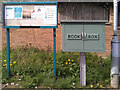
Notice board and book box
Beside the path near the entrance to King George V Park. The notice board has information relating to the park and local events, together with a copy of the Scottish Government's FACTS guidance relating to the Coronavirus (Covid-19) pandemic.
The book box is presumably a book-sharing scheme, but I didn't look inside to see.
Image: © Richard Sutcliffe
Taken: 5 May 2021
0.10 miles
10
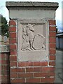
Gate pier to King George's Field
One of two brick gate piers at the entrance to King George's Field Image It bears the inscription:
GEORGE V
AD 1910-1936
Image: © Richard Sutcliffe
Taken: 5 May 2021
0.11 miles