IMAGES TAKEN NEAR TO
Oronsay Crescent, GLASGOW, G61 2PT
Introduction
This page details the photographs taken nearby to Oronsay Crescent, G61 2PT by members of the Geograph project.
The Geograph project started in 2005 with the aim of publishing, organising and preserving representative images for every square kilometre of Great Britain, Ireland and the Isle of Man.

There are currently over 7.5m images from over14,400 individuals and you can help contribute to the project by visiting https://www.geograph.org.uk
Image Map
Images are licensed for reuse under creativecommons.org/licenses/by-sa/2.0
Notes
- Clicking on the map will re-center to the selected point.
- The higher the marker number, the further away the image location is from the centre of the postcode.
Image Listing (53 Images Found)
Images are licensed for reuse under creativecommons.org/licenses/by-sa/2.0
Image
Details
Distance
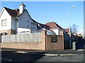
1
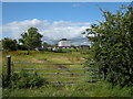
View through the gate, off Kessington Road, Bearsden
Looking towards Boclair Academy (in adjacent square). The track in the foreground turns to the right and leads to the side of Kessington Farm.
Image: © Richard Sutcliffe
Taken: 3 Aug 2015
0.06 miles
2
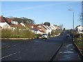
Suburban scene
Looking North along Inveroran Drive.
Image: © David Robertson
Taken: 4 Mar 2008
0.06 miles
3
Houses on Inveroran Drive, Bearsden
Viewed from near the edge of Templehill Wood. Boclair Academy is on the right.
Image: © Richard Sutcliffe
Taken: 3 Aug 2015
0.07 miles
4
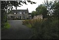
Kessington Farm
Looking from the end of Kessington Road, which at this point is a single track road that only goes to the farm. The OS map suggests that the road continues as a track up to the edge of Templehill Wood, but this is not the case.
Image: © Richard Sutcliffe
Taken: 3 Aug 2015
0.09 miles
5
Kessington Square
Fairly recent housing development in Kessington.
Image: © Stephen Sweeney
Taken: 25 Mar 2009
0.09 miles
6
Boclair Academy, Bearsden
Looking across rough pasture towards the local secondary school on the edge of Bearsden.
Image: © Richard Sutcliffe
Taken: 3 Aug 2015
0.10 miles
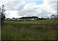
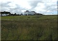
7
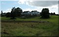
Country meets town at Kessington
The boundary between the urban area of Greater Glasgow and the rural farming areas of East Dunbartonshire.
Image: © Stephen Sweeney
Taken: 25 Mar 2009
0.11 miles
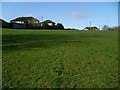
8
Houses on Woodvale Avenue
The backs of houses on Woodvale Avenue, seen from close to the edge of Templehill Wood. The majority of the grassland here gets an 'amenity cut', but some more natural habitat is left uncut.
Image: © Richard Sutcliffe
Taken: 3 Aug 2015
0.13 miles
9
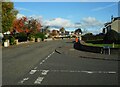
Junction of Albert Drive and Arisaig Drive
Suburban streets in Bearsden.
Image: © Richard Sutcliffe
Taken: 16 Oct 2020
0.14 miles
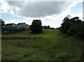
10
Houses on Woodvale Avenue
The backs of houses on Woodvale Avenue, seen from close to the edge of Templehill Wood.
Image: © Richard Sutcliffe
Taken: 3 Aug 2015
0.15 miles