IMAGES TAKEN NEAR TO
Roman Court, GLASGOW, G61 2NW
Introduction
This page details the photographs taken nearby to Roman Court, G61 2NW by members of the Geograph project.
The Geograph project started in 2005 with the aim of publishing, organising and preserving representative images for every square kilometre of Great Britain, Ireland and the Isle of Man.

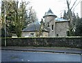
There are currently over 7.5m images from over14,400 individuals and you can help contribute to the project by visiting https://www.geograph.org.uk
Image Map
Images are licensed for reuse under creativecommons.org/licenses/by-sa/2.0
Notes
- Clicking on the map will re-center to the selected point.
- The higher the marker number, the further away the image location is from the centre of the postcode.
Image Listing (409 Images Found)
Images are licensed for reuse under creativecommons.org/licenses/by-sa/2.0
Image
Details
Distance
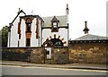
1
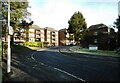
Roman Court
Part of Roman Court, a development of apartments built on and around the line of the Antonine Wall in Bearsden.
Image: © Richard Sutcliffe
Taken: 17 Jan 2023
0.02 miles
2
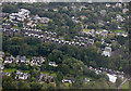
Bearsden from the air
The apartment blocks beyond the trees sit on the site of the Antonine Wall and the location of a Roman fort and bath house.
Image: © Thomas Nugent
Taken: 6 Sep 2019
0.03 miles
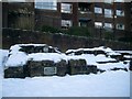
3
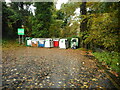
Recycling point
At the end of the short stay car park in Bearsden. The Manse Burn can just be seen on the far right.
Image: © Richard Sutcliffe
Taken: 20 Oct 2020
0.03 miles
4
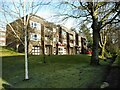
Roman Court
Part of Roman Court, a development of apartments built on and around the line of the Antonine Wall in Bearsden.
Image: © Richard Sutcliffe
Taken: 17 Jan 2023
0.04 miles
5
House on Roman Road
With an interesting-looking stair tower.
Image: © Richard Sutcliffe
Taken: 17 Jan 2023
0.05 miles
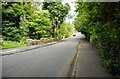
6
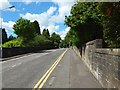
Roman Road, Bearsden
The subject is as in Image, but the view is in the opposite direction.
The road follows the line of the ancient Military Way, which ran parallel to, and to the south of, the rampart of the Antonine Wall. From about 20 metres to about 120 metres ahead, the ground on either side of the road was formerly the site of Bearsden Roman Fort.
As for the part of the road from which the picture was taken, the ground on either side was formerly the eastern annexe of that fort. The annexe contained a bath-house (Image), whose remains are just a few metres to the right (north) of the photographer's position: http://www.geograph.org.uk/snippet/13721
Image: © Lairich Rig
Taken: 3 Jul 2015
0.06 miles
7
Frigidarium, Bearsden Roman Baths
The frigidarium was the cold room of a Roman bath house.
Image: © Stephen Sweeney
Taken: 10 Jan 2010
0.06 miles
8
10 Drymen Road
A distinctive property in Bearsden.
Image: © Richard Sutcliffe
Taken: 14 Sep 2019
0.07 miles
9
Grange Road, Bearsden
The bridge is crossing the Manse Burn.
Image: © Richard Sutcliffe
Taken: 29 Jul 2020
0.07 miles
10
![Roman Road [A808], Bearsden](https://s3.geograph.org.uk/geophotos/04/53/32/4533259_939a03c1_120x120.jpg)
Roman Road [A808], Bearsden
The site of a Roman bath house, overtaken by modern developments.
Image: © M J Richardson
Taken: 20 Jun 2015
0.07 miles