IMAGES TAKEN NEAR TO
Woodvale Avenue, GLASGOW, G61 2NS
Introduction
This page details the photographs taken nearby to Woodvale Avenue, G61 2NS by members of the Geograph project.
The Geograph project started in 2005 with the aim of publishing, organising and preserving representative images for every square kilometre of Great Britain, Ireland and the Isle of Man.

There are currently over 7.5m images from over14,400 individuals and you can help contribute to the project by visiting https://www.geograph.org.uk
Image Map
Images are licensed for reuse under creativecommons.org/licenses/by-sa/2.0
Notes
- Clicking on the map will re-center to the selected point.
- The higher the marker number, the further away the image location is from the centre of the postcode.
Image Listing (61 Images Found)
Images are licensed for reuse under creativecommons.org/licenses/by-sa/2.0
Image
Details
Distance
1
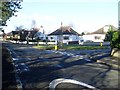
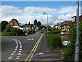
Woodvale Avenue at Albert Drive
Meeting of two roads in the residential area of Kessington.
Image: © Stephen Sweeney
Taken: 25 Mar 2009
0.04 miles
2
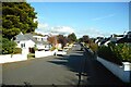
Lochaber Road
A suburban street in Bearsden.
Image: © Richard Sutcliffe
Taken: 16 Oct 2020
0.10 miles
3
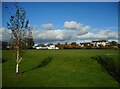
Playing field, King George V Park
The playing field is a King George's Field. These are public open spaces in the United Kingdom dedicated to the memory of King George https://en.wikipedia.org/wiki/King_George%27s_Fields.
Image: © Richard Sutcliffe
Taken: 16 Oct 2020
0.10 miles
4

Roundabout, Rannoch Drive
Spiers Road runs from left to right.
Image: © Richard Sutcliffe
Taken: 5 May 2021
0.15 miles
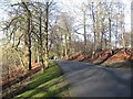
5
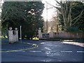
Road into Glasgow Golf Club
At Killermont, just off Maryhill Road.
Image: © Stephen Sweeney
Taken: 25 Mar 2009
0.16 miles
6
Lochaber Road, Bearsden
Junction with Rannoch Drive.
Image: © Richard Sutcliffe
Taken: 3 Aug 2015
0.16 miles
7
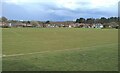
King George V Field
Laid out as two football pitches.
King George's fields are public open spaces in the United Kingdom dedicated to the memory of King George V and protected by Fields in Trust in perpetuity. See https://en.wikipedia.org/wiki/King_George%27s_Fields.
Image: © Richard Sutcliffe
Taken: 5 May 2021
0.16 miles
8
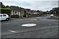
Mini-roundabout
At the junction of Rannoch Drive and Cluny Avenue.
Image: © Richard Sutcliffe
Taken: 14 Sep 2021
0.17 miles
9
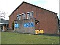
Killermont Parish Church
This part of the church dates from 1957. A cafe is operated in the church on weekday mornings.
Image: © Richard Sutcliffe
Taken: 5 May 2021
0.17 miles
10
Approaching the golf club
The drive into the Killermont Golf Club.
Image: © David Robertson
Taken: 4 Mar 2008
0.17 miles