IMAGES TAKEN NEAR TO
Rannoch Drive, GLASGOW, G61 2LD
Introduction
This page details the photographs taken nearby to Rannoch Drive, G61 2LD by members of the Geograph project.
The Geograph project started in 2005 with the aim of publishing, organising and preserving representative images for every square kilometre of Great Britain, Ireland and the Isle of Man.

There are currently over 7.5m images from over14,400 individuals and you can help contribute to the project by visiting https://www.geograph.org.uk
Image Map
Images are licensed for reuse under creativecommons.org/licenses/by-sa/2.0
Notes
- Clicking on the map will re-center to the selected point.
- The higher the marker number, the further away the image location is from the centre of the postcode.
Image Listing (29 Images Found)
Images are licensed for reuse under creativecommons.org/licenses/by-sa/2.0
Image
Details
Distance
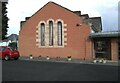
1
Killermont Parish Church
This part of the church dates from 1957. A cafe is operated in the church on weekday mornings.
Image: © Richard Sutcliffe
Taken: 5 May 2021
0.01 miles
2
Killermont Parish Church
This is the original part of the church, built between 1935 and 1937.
Image: © Richard Sutcliffe
Taken: 5 May 2021
0.01 miles
3
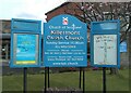
Church noticeboard
At Killermont Parish Church.
Image: © Richard Sutcliffe
Taken: 5 May 2021
0.02 miles
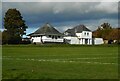
4
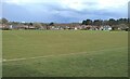
King George V Field
Laid out as two football pitches.
King George's fields are public open spaces in the United Kingdom dedicated to the memory of King George V and protected by Fields in Trust in perpetuity. See https://en.wikipedia.org/wiki/King_George%27s_Fields.
Image: © Richard Sutcliffe
Taken: 5 May 2021
0.02 miles
5
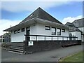
The Pagoda, King George V Park
The pagoda was probably built in the 1950s, associated with the adjacent King George V field. It was used as a changing pavilion but then lay unused for 25 years. It has recently been refurbished as the all new 'Milngavie and Bearsden Men's Shed' which includes a workshop and recreational meeting rooms.
Image: © Richard Sutcliffe
Taken: 5 May 2021
0.03 miles
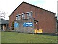
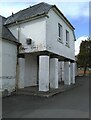
6
Pavilion, King George V Park
At Killermont, Bearsden.
Image: © Richard Sutcliffe
Taken: 16 Oct 2020
0.04 miles
7
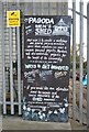
Blackboard outside the Men's Shed
The blackboard advertises the 'Milngavie and Bearsden Men's Shed'.
Image: © Richard Sutcliffe
Taken: 5 May 2021
0.04 miles
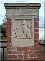
8
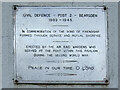
Plaque on the pavilion, King George V Park
The plaque is on one of the pillars at the entrance to the building Image
CIVIL DEFENCE – POST 2 – BEARSDEN
1939-1945.
IN COMMEMORATION OF THE BOND OF FRIENDSHIP
FORMED THROUGH SERVICE AND MUTUAL SACRIFICE.
ERECTED BY THE AIR RAID WARDENS WHO
SERVED AT THE POST WITHIN THIS PAVILION
DURING THE SECOND WORLD WAR.
PEACE IN OUR TIME, O LORD.
Image: © Richard Sutcliffe
Taken: 5 May 2021
0.04 miles
9
Pavilion next to the pagoda
Just to the north of the pagoda Image, overlooking King George V Field. The building was used as a Civil Defence Post during the Second World War Image
Image: © Richard Sutcliffe
Taken: 5 May 2021
0.04 miles
10
Gate pier to King George's Field
One of two brick gate piers at the entrance to King George's Field Image It bears the inscription:
KING GEORGE'S
FIELD
Image: © Richard Sutcliffe
Taken: 5 May 2021
0.05 miles