IMAGES TAKEN NEAR TO
Kessington Road, GLASGOW, G61 2HL
Introduction
This page details the photographs taken nearby to Kessington Road, G61 2HL by members of the Geograph project.
The Geograph project started in 2005 with the aim of publishing, organising and preserving representative images for every square kilometre of Great Britain, Ireland and the Isle of Man.

There are currently over 7.5m images from over14,400 individuals and you can help contribute to the project by visiting https://www.geograph.org.uk
Image Map
Images are licensed for reuse under creativecommons.org/licenses/by-sa/2.0
Notes
- Clicking on the map will re-center to the selected point.
- The higher the marker number, the further away the image location is from the centre of the postcode.
Image Listing (56 Images Found)
Images are licensed for reuse under creativecommons.org/licenses/by-sa/2.0
Image
Details
Distance

2

Garage sundial
A modern take on old technology.
Image: © Richard Sutcliffe
Taken: 24 Jan 2022
0.06 miles
3
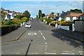
Borland Road
Residential street in Bearsden.
Image: © Richard Sutcliffe
Taken: 10 Jun 2019
0.06 miles
4

Old Milepost by MacFarlane Road, Bearsden
Glasgow curved cast iron post by the UC road, in parish of New Kilpatrick (East Dunbartonshire), McFarlane Road (off A81), Bearsden, opposite No. 35, back to garden wall, East side of road.
Inscription reads:-
GLASGOW
ROYAL EXCHANGE
{pointing hand->}
BALFRON 14
ABERFOIL
21
{<-pointing hand}
Grade C(S) listed.
Reference: LB48601 http://portal.historicenvironment.scot/designation/LB48601
Surveyed
Milestone Society National ID: ED_GWAF05
Image: © Milestone Society
Taken: Unknown
0.08 miles
5
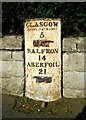
Milepost on MacFarlane Road
This milepost is located on what was at one time the main road from Aberfoyle and Balfron to Glasgow. MacFarlane Road is now a quiet side street, as it is by-passed by the A81 Milngavie Road to the west. It is Category C listed [http://portal.historicenvironment.scot/designation/LB48601] and dates from 1861.
This milepost was photographed in 2012 [https://www.geograph.org.uk/photo/6060939], but is now looking a bit rusty compared with then.
Image: © Richard Sutcliffe
Taken: 10 Jun 2019
0.08 miles
6

Kessington Drive
Looking towards the shops on Milngavie Road.
Image: © Richard Sutcliffe
Taken: 24 Jan 2022
0.08 miles
7

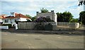
Roadworks at the roundabout
Resurfacing work being undertaken where Clathic Avenue and Killermont Road meet Kessington Road. It looks like the work is long overdue.
Image: © Richard Sutcliffe
Taken: 24 Jan 2022
0.09 miles
8
Electricity sub-station (MacFarlane Road 40)
At the corner of Borland Road and MacFarlane Road.
Image: © Richard Sutcliffe
Taken: 10 Jun 2019
0.09 miles
9
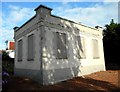
Electricity sub-station (MacFarlane Road 40)
At the corner of Borland Road and MacFarlane Road.
Image: © Richard Sutcliffe
Taken: 10 Jun 2019
0.09 miles
10

Road signs
Temporary signs on Clathic Avenue while resurfacing work is undertaken.
Image: © Richard Sutcliffe
Taken: 24 Jan 2022
0.09 miles