IMAGES TAKEN NEAR TO
Carrickarden Road, GLASGOW, G61 2DZ
Introduction
This page details the photographs taken nearby to Carrickarden Road, G61 2DZ by members of the Geograph project.
The Geograph project started in 2005 with the aim of publishing, organising and preserving representative images for every square kilometre of Great Britain, Ireland and the Isle of Man.

There are currently over 7.5m images from over14,400 individuals and you can help contribute to the project by visiting https://www.geograph.org.uk
Image Map
Images are licensed for reuse under creativecommons.org/licenses/by-sa/2.0
Notes
- Clicking on the map will re-center to the selected point.
- The higher the marker number, the further away the image location is from the centre of the postcode.
Image Listing (57 Images Found)
Images are licensed for reuse under creativecommons.org/licenses/by-sa/2.0
Image
Details
Distance
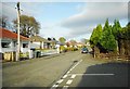
1
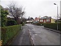
Carrickarden Road
Not a through route to Drymen Road for vehicles, it is blocked by a row of trees.
Image: © Richard Webb
Taken: 19 Jan 2014
0.01 miles
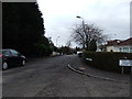
2
Rat run blocking, Bearsden style
No through road, care of a row of trees. Carrickarden Road, Bearsden.
Image: © Richard Webb
Taken: 19 Jan 2014
0.03 miles
3
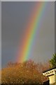
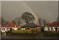
Rainbow, Bearsden
A very bright one in low sunlight. As usual no sign of the mysterious 7th colour, indigo . It is believed that having two names for blue could boost the number of colours to the favoured 7. Things are further complicated with many cultures having little distinction between green and blue.
Image: © Richard Webb
Taken: 19 Jan 2014
0.04 miles
4
Carrickarden Road, Bearsden
Road doesn't appear to have been resurfaced since I lived here (50 years ago!)
Image: © David Brown
Taken: 2 May 2013
0.06 miles
5
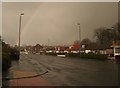
Houses, Milngavie Road
Houses on Milngavie Road (A81) with rainbow during a torrential shower of rain.
Image: © Richard Sutcliffe
Taken: 18 Feb 2016
0.09 miles
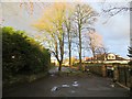
6
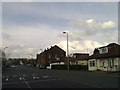
Milngavie Road at Carrickarden Road
Image: © Elliott Simpson
Taken: 26 Apr 2014
0.10 miles
7
Houses, Milngavie Road
Three houses on Milngavie Road (A81) with double rainbow during a torrential shower of rain.
Image: © Richard Sutcliffe
Taken: 18 Feb 2016
0.11 miles
8
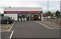
New Sainsbury's Local, Milngavie Road
This small supermarket opened in August 2015 on the site of a former petrol filling station.
Image: © Richard Sutcliffe
Taken: 2 Sep 2015
0.11 miles
9
Gray Drive
At the junction with Moore Drive.
Image: © Richard Sutcliffe
Taken: 5 Apr 2017
0.11 miles
10
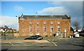
Kessington Hall
Built in 1924 and originally housed an electricity sub-station to power the Milngavie tram route. Now a public hall.
Image: © Richard Sutcliffe
Taken: 12 Apr 2017
0.11 miles