IMAGES TAKEN NEAR TO
Ilay Road, GLASGOW, G61 1QQ
Introduction
This page details the photographs taken nearby to Ilay Road, G61 1QQ by members of the Geograph project.
The Geograph project started in 2005 with the aim of publishing, organising and preserving representative images for every square kilometre of Great Britain, Ireland and the Isle of Man.

There are currently over 7.5m images from over14,400 individuals and you can help contribute to the project by visiting https://www.geograph.org.uk
Image Map
Images are licensed for reuse under creativecommons.org/licenses/by-sa/2.0
Notes
- Clicking on the map will re-center to the selected point.
- The higher the marker number, the further away the image location is from the centre of the postcode.
Image Listing (26 Images Found)
Images are licensed for reuse under creativecommons.org/licenses/by-sa/2.0
Image
Details
Distance
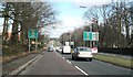
1
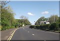
Bearsden Road approaching Hay Avenue junction
Image: © John Firth
Taken: 17 May 2013
0.08 miles
2
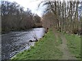
Bank of the River Kelvin
Looking upstream.
Image: © Richard Sutcliffe
Taken: 9 Apr 2022
0.10 miles
3
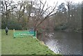
Bank of the River Kelvin
The structure on the bank is for sand martins Image The prospective passing angler may not be aware that fishing is by permit only, through the River Kelvin Angling Association!
Image: © Richard Sutcliffe
Taken: 9 Apr 2022
0.14 miles
4
Sand martin nesting bank
On the north bank of the River Kelvin in Garscube Estate. This strange-looking construction, completed in March 2021 is for sand martins to nest in. Glasgow University’s Urban Biodiversity Working Group obtained funding from the Blodwyn Lloyd Binns Bequest, through Glasgow Natural History Society. This enabled them to construct this box, filled with sand and with 48 nest holes on the side facing the river, allowing sand martins to get access. This side of the structure can be opened, giving access to the tunnels and nests, so that young birds can be easily ringed (under licence) for migratory studies.
Image: © Richard Sutcliffe
Taken: 9 Apr 2022
0.14 miles
6
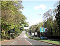
Switchback Road approaching Henderland Road
Image: © John Firth
Taken: 17 May 2013
0.17 miles
7
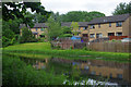
Forth and Clyde Canal, Netherton
The houses reflected in the quiet water are on Howth terrace.
Image: © Stephen McKay
Taken: 25 Jun 2019
0.19 miles
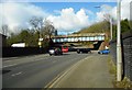
8
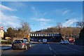
Railway bridge over the A739 Bearsden Road
Image: © Alpin Stewart
Taken: 27 Dec 2017
0.20 miles
10

Bearsden Road with railway bridge
The A739 road becomes a dual carriageway beyond the bridge.
Image: © Stephen Craven
Taken: 25 Jun 2019
0.20 miles