IMAGES TAKEN NEAR TO
Stirling Avenue, GLASGOW, G61 1PE
Introduction
This page details the photographs taken nearby to Stirling Avenue, G61 1PE by members of the Geograph project.
The Geograph project started in 2005 with the aim of publishing, organising and preserving representative images for every square kilometre of Great Britain, Ireland and the Isle of Man.

There are currently over 7.5m images from over14,400 individuals and you can help contribute to the project by visiting https://www.geograph.org.uk
Image Map
Images are licensed for reuse under creativecommons.org/licenses/by-sa/2.0
Notes
- Clicking on the map will re-center to the selected point.
- The higher the marker number, the further away the image location is from the centre of the postcode.
Image Listing (122 Images Found)
Images are licensed for reuse under creativecommons.org/licenses/by-sa/2.0
Image
Details
Distance
1
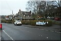
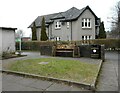
Houses on Maxwell Avenue
The houses (67-71 Maxwell Avenue) are a block of three houses built as part of the garden suburb of Westerton in 1913-15. They are Category B listed http://portal.historicenvironment.scot/designation/LB22154.
The banner 'Save our Green' refers to a current threat to green spaces in Westerton.
Image: © Richard Sutcliffe
Taken: 9 Feb 2023
0.03 miles
2
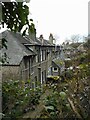
The rear of houses on Maxwell Avenue
These houses (73-79 Maxwell Avenue) are a block of four houses built as part of the garden suburb of Westerton in 1913-15. They are Category C listed http://portal.historicenvironment.scot/designation/LB22155.
Image: © Richard Sutcliffe
Taken: 9 Feb 2023
0.03 miles
3
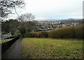
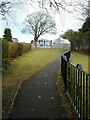
Path down to Maxwell Avenue
Looking down a steep path from Crarae Avenue to Maxwell Avenue.
Image: © Richard Sutcliffe
Taken: 9 Feb 2023
0.04 miles
4
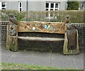
Seat beside Westerton Hall and Library
The carved seat features a variety of wildlife. Westerton is part of Bearsden - hence the bear.
Image: © Richard Sutcliffe
Taken: 9 Feb 2023
0.05 miles
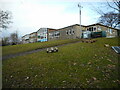
5
Westerton Primary School
Seen from the path from Crarae Avenue to Maxwell Avenue.
Image: © Richard Sutcliffe
Taken: 9 Feb 2023
0.05 miles
6
House on Maxwell Avenue
Next to Westerton Hall and Library. The carved seat Image features wildlife.
Image: © Richard Sutcliffe
Taken: 9 Feb 2023
0.05 miles
7
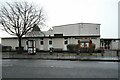
Westerton Hall and Library
On Maxwell Avenue.
Image: © Richard Sutcliffe
Taken: 9 Feb 2023
0.05 miles
8
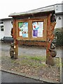
Notice board, Westerton Hall and Library
With a carved wildlife-themed surround. Westerton is part of Bearsden - hence the two bears.
Image: © Richard Sutcliffe
Taken: 9 Feb 2023
0.05 miles
9
Westerton Primary School
Seen from the footpath leading down to Maxwell Avenue from Crarae Avenue.
Image: © Richard Sutcliffe
Taken: 9 Feb 2023
0.05 miles
10
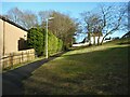
Path from Stirling Avenue to Westfield Drive
A steeper path than it looks.
Image: © Richard Sutcliffe
Taken: 9 Feb 2023
0.05 miles