IMAGES TAKEN NEAR TO
Elderbank, GLASGOW, G61 1ND
Introduction
This page details the photographs taken nearby to Elderbank, G61 1ND by members of the Geograph project.
The Geograph project started in 2005 with the aim of publishing, organising and preserving representative images for every square kilometre of Great Britain, Ireland and the Isle of Man.

There are currently over 7.5m images from over14,400 individuals and you can help contribute to the project by visiting https://www.geograph.org.uk
Image Map
Images are licensed for reuse under creativecommons.org/licenses/by-sa/2.0
Notes
- Clicking on the map will re-center to the selected point.
- The higher the marker number, the further away the image location is from the centre of the postcode.
Image Listing (20 Images Found)
Images are licensed for reuse under creativecommons.org/licenses/by-sa/2.0
Image
Details
Distance
1
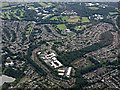
Canniesburn from the air
St Germains Loch is just visible in the lower left corner.
Image: © Thomas Nugent
Taken: 14 Sep 2015
0.03 miles
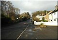
2
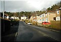
Stirling Avenue
Looking north from Monreith Avenue to the end of Stirling Avenue, this part of which is a cul-de-sac.
Image: © Richard Sutcliffe
Taken: 9 Feb 2023
0.09 miles
3
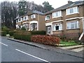
Houses on Maxwell Avenue
In Westerton.
Image: © Stephen Sweeney
Taken: 20 Jan 2009
0.10 miles
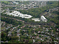
4
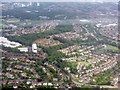
Bearsden from the air
Seen from the northwest on the way into Glasgow Airport.
Image: © M J Richardson
Taken: 20 Jun 2015
0.12 miles
5
Maxwell Avenue
Looking up the hill from Monreith Avenue.
Image: © Richard Sutcliffe
Taken: 9 Feb 2023
0.12 miles
6
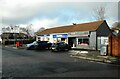
Keystore and hairdressers
Keystore and Gillian Copeland Hairdressing. On Monreith Drive.
Image: © Richard Sutcliffe
Taken: 9 Feb 2023
0.15 miles
7
Canniesburn from the air
The prominent white buildings are on the site of the former Canniesburn Hospital which closed in 2003. Some Category B Listed hospital buildings have been retained within the development.
Image: © Thomas Nugent
Taken: 5 May 2022
0.15 miles
8
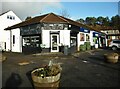
Hairdressers and Keystore
Hair By Mellow Moods next to the Keystone store on Monreith Avenue.
Image: © Richard Sutcliffe
Taken: 9 Feb 2023
0.15 miles
9
Houses on Stirling Avenue
Seen from Monreith Avenue.
Image: © Richard Sutcliffe
Taken: 9 Feb 2023
0.15 miles
10
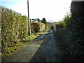
Back lane
The lane backs onto properties on Maxwell Avenue and Stirling Avenue and runs for 160 metres from Monreith Avenue (from where photographed) to the southern end of Stirling Avenue.
Image: © Richard Sutcliffe
Taken: 9 Feb 2023
0.17 miles