IMAGES TAKEN NEAR TO
Maxwell Avenue, GLASGOW, G61 1HS
Introduction
This page details the photographs taken nearby to Maxwell Avenue, G61 1HS by members of the Geograph project.
The Geograph project started in 2005 with the aim of publishing, organising and preserving representative images for every square kilometre of Great Britain, Ireland and the Isle of Man.

There are currently over 7.5m images from over14,400 individuals and you can help contribute to the project by visiting https://www.geograph.org.uk
Image Map
Images are licensed for reuse under creativecommons.org/licenses/by-sa/2.0
Notes
- Clicking on the map will re-center to the selected point.
- The higher the marker number, the further away the image location is from the centre of the postcode.
Image Listing (18 Images Found)
Images are licensed for reuse under creativecommons.org/licenses/by-sa/2.0
Image
Details
Distance
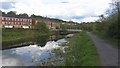
1
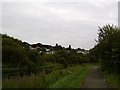
Houses in Westerton
From the canal bank.
Image: © Stephen Sweeney
Taken: 9 Aug 2007
0.09 miles
2
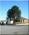
Monkey Puzzle trees, Wardlaw Road
Two Monkey Puzzle trees in a garden at the corner of Wardlaw Road and Ravelston Road.
Image: © Richard Sutcliffe
Taken: 4 May 2017
0.09 miles
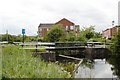
4
Footbridge over the Forth & Clyde Canal
At Netherton in north Glasgow.
Image: © Gordon Brown
Taken: 24 Jul 2017
0.15 miles
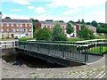
5
![Forth and Clyde Canal [54]](https://s1.geograph.org.uk/geophotos/06/25/03/6250309_9089dba4_120x120.jpg)
Forth and Clyde Canal [54]
The bridge at Old Farm Road is a swing bridge.
The Forth and Clyde Canal was completed in 1790 and it provided a route for vessels between the Firth of Forth and the Firth of Clyde at the narrowest part (35 miles, 56km) of the Scottish Lowlands. Closed in 1963, the canal became semi-derelict. Millennium funds were used to regenerate the canal. The main line of the canal is a Scheduled Monument with details at: http://portal.historicenvironment.scot/designation/SM6774
Image: © Michael Dibb
Taken: 25 Jun 2019
0.15 miles
6
Forth and Clyde Canal
The canal at Netherton.
Image: © Richard Webb
Taken: 9 May 2012
0.15 miles
7
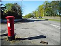
Junction of Switchback Road and Wardlaw Road
The George V pillar box is postbox number G61 1011D [http://www.geograph.org.uk/photo/5376824].
Image: © Richard Sutcliffe
Taken: 4 May 2017
0.18 miles
8
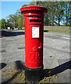
George V pillar box
George V pillar box, postbox number G61 1011D. At the junction of Switchback Road (A739) and Wardlaw Road.
Image: © Richard Sutcliffe
Taken: 4 May 2017
0.18 miles
9
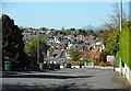
View from Ravelston Road
Looking down Ravelston Road over houses in nearby streets. In the far distance is the distinctive shape of Dumgoyne, 12km to the north.
Image: © Richard Sutcliffe
Taken: 4 May 2017
0.18 miles
10
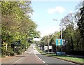
Switchback Road approaching Henderland Road
Image: © John Firth
Taken: 17 May 2013
0.19 miles