IMAGES TAKEN NEAR TO
Ilay Avenue, GLASGOW, G61 1HP
Introduction
This page details the photographs taken nearby to Ilay Avenue, G61 1HP by members of the Geograph project.
The Geograph project started in 2005 with the aim of publishing, organising and preserving representative images for every square kilometre of Great Britain, Ireland and the Isle of Man.

There are currently over 7.5m images from over14,400 individuals and you can help contribute to the project by visiting https://www.geograph.org.uk
Image Map
Images are licensed for reuse under creativecommons.org/licenses/by-sa/2.0
Notes
- Clicking on the map will re-center to the selected point.
- The higher the marker number, the further away the image location is from the centre of the postcode.
Image Listing (48 Images Found)
Images are licensed for reuse under creativecommons.org/licenses/by-sa/2.0
Image
Details
Distance
1
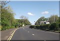
Bearsden Road approaching Hay Avenue junction
Image: © John Firth
Taken: 17 May 2013
0.05 miles
2
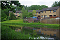
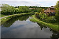
Forth and Clyde Canal, Netherton
The houses reflected in the quiet water are on Howth terrace.
Image: © Stephen McKay
Taken: 25 Jun 2019
0.10 miles
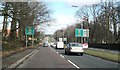
4
Switchback Road approaching Henderland Road
Image: © John Firth
Taken: 17 May 2013
0.12 miles
5
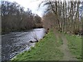
Bank of the River Kelvin
Looking upstream.
Image: © Richard Sutcliffe
Taken: 9 Apr 2022
0.12 miles
6
Forth and Clyde Canal
Looking north from Howth Drive Bridge.
Image: © Richard Sutcliffe
Taken: 9 Jun 2015
0.13 miles
7
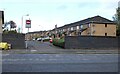
Howth Drive
Houses on Howth Drive, seen from across the A739, Bearsden Road.
Image: © Richard Sutcliffe
Taken: 13 Oct 2023
0.17 miles
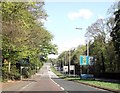
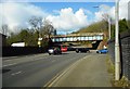
8
Railway bridge over the A739 Bearsden Road
Image: © Alpin Stewart
Taken: 27 Dec 2017
0.19 miles
10

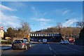
Bearsden Road with railway bridge
The A739 road becomes a dual carriageway beyond the bridge.
Image: © Stephen Craven
Taken: 25 Jun 2019
0.19 miles