IMAGES TAKEN NEAR TO
Tweed Drive, GLASGOW, G61 1EL
Introduction
This page details the photographs taken nearby to Tweed Drive, G61 1EL by members of the Geograph project.
The Geograph project started in 2005 with the aim of publishing, organising and preserving representative images for every square kilometre of Great Britain, Ireland and the Isle of Man.

There are currently over 7.5m images from over14,400 individuals and you can help contribute to the project by visiting https://www.geograph.org.uk
Image Map
Images are licensed for reuse under creativecommons.org/licenses/by-sa/2.0
Notes
- Clicking on the map will re-center to the selected point.
- The higher the marker number, the further away the image location is from the centre of the postcode.
Image Listing (30 Images Found)
Images are licensed for reuse under creativecommons.org/licenses/by-sa/2.0
Image
Details
Distance
1
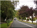
Looking downhill on Pendicle Road
It's no fun getting to the top, but it's worth it!
Image: © Stephen Sweeney
Taken: 2 Aug 2007
0.11 miles
2
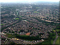
Colquhoun Park from the air
The pond is part of the Colquhoun Park Flood Alleviation Scheme. See Image for more details of the scheme.
See also Image
Image: © Thomas Nugent
Taken: 6 Sep 2019
0.12 miles
3
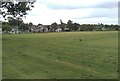
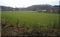
Playing field, Colquhoun Park
A rugby pitch beside Conan Avenue.
Image: © Richard Sutcliffe
Taken: 7 Aug 2021
0.13 miles
4
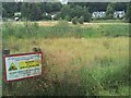
Danger sign
The sign beside the wetland area in Colquhoun Park to absorb flood water as a Flood Alleviation Scheme warns of danger: soft mud and risk of drowning.
Image: © Richard Sutcliffe
Taken: 7 Aug 2021
0.15 miles
5
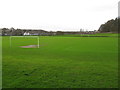
Colquhoun Park, Bearsden
Colquhoun Park is a large open park. It has football pitches and a rugby pitch and are available to the public.
Image: © G Laird
Taken: 28 Dec 2013
0.15 miles
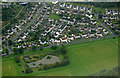
6
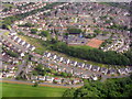
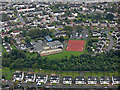
Colquhoun Park Primary School
The arc of houses is on Annan Drive. Seen from the air on the way to Glasgow Airport.
Image: © M J Richardson
Taken: 20 Jun 2015
0.17 miles
7
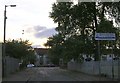
The Road into Drumchapel
Note the pair of shoes hanging from the phone cable
Image: © Chris Upson
Taken: 2 Sep 2005
0.17 miles
8
Westerton from the air
The railway junction near Westerton station can be seen near the top of the photo. The houses under construction in the foreground are on Annan Drive.
Image: © Thomas Nugent
Taken: 9 Jun 2012
0.17 miles
9
Football pitch, Colquhoun Park
Seen from Station Road.
Image: © Richard Sutcliffe
Taken: 27 Dec 2021
0.17 miles
10
Colquhoun Park Primary School from the air
Some children can be seen on the sports field. Annan Drive is in the foreground.
School web site: http://www.colquhounpark.e-dunbarton.sch.uk/ .
Image: © Thomas Nugent
Taken: 6 Sep 2019
0.18 miles