IMAGES TAKEN NEAR TO
Dumbarton Road, GLASGOW, G60 5NB
Introduction
This page details the photographs taken nearby to Dumbarton Road, G60 5NB by members of the Geograph project.
The Geograph project started in 2005 with the aim of publishing, organising and preserving representative images for every square kilometre of Great Britain, Ireland and the Isle of Man.

There are currently over 7.5m images from over14,400 individuals and you can help contribute to the project by visiting https://www.geograph.org.uk
Image Map
Images are licensed for reuse under creativecommons.org/licenses/by-sa/2.0
Notes
- Clicking on the map will re-center to the selected point.
- The higher the marker number, the further away the image location is from the centre of the postcode.
Image Listing (132 Images Found)
Images are licensed for reuse under creativecommons.org/licenses/by-sa/2.0
Image
Details
Distance
1
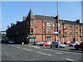
Old Kilpatrick tenements
The shop in the image is still known locally as Paul's, after Archibald Paul, who was the owner seventy years ago.
Image: © Stephen Sweeney
Taken: 27 Jul 2008
0.02 miles

3
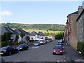
Gavinburn Place
Viewed from the path by the canal.
Image: © Stephen Sweeney
Taken: 27 Jul 2008
0.05 miles
4
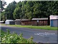
Huts along Portpatrick Road
Beside the canal in Old Kilpatrick.
Image: © Stephen Sweeney
Taken: 27 Jul 2008
0.06 miles
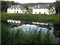
5
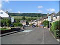
Kirk Crescent
Nice view to the Kilpatrick Hills from here.
Image: © Stephen Sweeney
Taken: 27 Jul 2008
0.06 miles
6
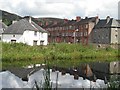
Gavinburn Place
Seen from the Forth and Clyde Canal. The Kilpatrick Hills in the background.
Image: © Richard Webb
Taken: 1 Sep 2009
0.06 miles
7
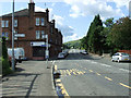
Dumbarton Road Old Kilpatrick
Looking West at Mansfield Crescent.
Image: © Thomas Nugent
Taken: 7 Aug 2010
0.06 miles
8
Forth and Clyde Canal
The canal passing Portpatrick Road.
Image: © Richard Webb
Taken: 1 Sep 2009
0.07 miles
9
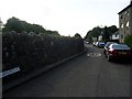
Portpatrick Road
Quiet street by the canal in Old Kilpatrick.
Image: © Stephen Sweeney
Taken: 27 Jul 2008
0.08 miles
10
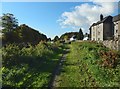
Path beside the Forth and Clyde Canal
The path is bounded by the Forth and Clyde Canal on the left (south) and by Portpatrick Road on the right. On the other side of the canal, there is a more substantial footpath, which also served as a cycle route. On this side, there is just a grassy path leading to a nearby bascule bridge (Image) over the canal.
Image: © Lairich Rig
Taken: 16 Oct 2015
0.08 miles