IMAGES TAKEN NEAR TO
Station Road, GLASGOW, G60 5LT
Introduction
This page details the photographs taken nearby to Station Road, G60 5LT by members of the Geograph project.
The Geograph project started in 2005 with the aim of publishing, organising and preserving representative images for every square kilometre of Great Britain, Ireland and the Isle of Man.

There are currently over 7.5m images from over14,400 individuals and you can help contribute to the project by visiting https://www.geograph.org.uk
Image Map
Images are licensed for reuse under creativecommons.org/licenses/by-sa/2.0
Notes
- Clicking on the map will re-center to the selected point.
- The higher the marker number, the further away the image location is from the centre of the postcode.
Image Listing (141 Images Found)
Images are licensed for reuse under creativecommons.org/licenses/by-sa/2.0
Image
Details
Distance
1
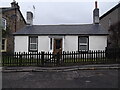
Former tollhouse
Surveyed by the Milestone Society. In Old Kilpatrick between the A814 and A82 just west of the railway bridge and station. The Toll House, Hillview Terrace. Standing between two later 2 storey houses.
Image: © Chris Minto
Taken: 18 Feb 2015
0.03 miles
2
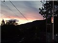
Red Sky At Night, Old Kilpatrick
Sunset over the village, viewed from the train station.
Image: © Stephen Sweeney
Taken: 28 May 2007
0.04 miles
4
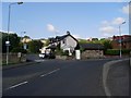
Old Kilpatrck housing
On the corner of Station Road and Thistleneuk.
Image: © Stephen Sweeney
Taken: 27 Jul 2008
0.05 miles
5
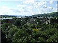
Old Kilpatrick
Viewed from the Erskine Bridge, with the Clyde and Dumbarton Rock in the distance.
Image: © Thomas Nugent
Taken: 7 Aug 2010
0.06 miles
6
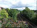
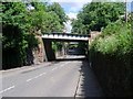
Railway at Old Kilpatrick
Looking east towards Kilpatrick station from the bridge near Mount Pleasant Drive.
Image: © Thomas Nugent
Taken: 7 Aug 2010
0.06 miles
9
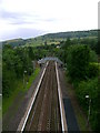
North Clyde Line from Erskine Bridge
The North Clyde Line passing through Kilpatrick station on its way to Dumbarton and ultimately, after splitting at Dalreoch, either Helensburgh or Balloch.
Image: © Mark Nightingale
Taken: 6 Jul 2009
0.08 miles
10
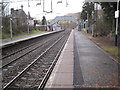
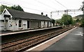
Kilpatrick railway station, West Dunbartonshire
Opened in 1858 by the Glasgow, Dumbarton & Helensburgh Railway. View north west towards Bowling and Helensburgh.
Image: © Nigel Thompson
Taken: 29 Dec 2012
0.08 miles