IMAGES TAKEN NEAR TO
Erskine Ferry Road, GLASGOW, G60 5EU
Introduction
This page details the photographs taken nearby to Erskine Ferry Road, G60 5EU by members of the Geograph project.
The Geograph project started in 2005 with the aim of publishing, organising and preserving representative images for every square kilometre of Great Britain, Ireland and the Isle of Man.

There are currently over 7.5m images from over14,400 individuals and you can help contribute to the project by visiting https://www.geograph.org.uk
Image Map (Loading...)


Getting Data...Please wait
Leaflet Map data © OpenStreetMap
Images are licensed for reuse under creativecommons.org/licenses/by-sa/2.0
Notes
- Clicking on the map will re-center to the selected point.
- The higher the marker number, the further away the image location is from the centre of the postcode.
Image Listing (155 Images Found)
Images are licensed for reuse under creativecommons.org/licenses/by-sa/2.0
Image
Details
Distance
1
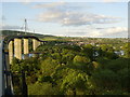
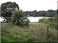
River Clyde and Old Kilpatrick from Erskine Bridge
One of many stunning views the bridge has to offer.
Image: © Stephen Sweeney
Taken: 20 May 2007
0.02 miles
2
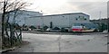
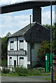
Subsea 7
The road is called Erskine Ferry Road: followed to the right of the building, it leads to the old Image The road branching off to the left is also reckoned as part of Erskine Ferry Road, but simply provides access to other business premises.
Image: © Lairich Rig
Taken: 8 Feb 2013
0.04 miles
3
Erskine Ferry Terminal
Before the Erskine Bridge was built, a ferry would leave from here to take passengers and vehicles over the water. The terminal at the Erskine side can be seen in this picture too.
Image: © Stephen Sweeney
Taken: 24 Jan 2007
0.05 miles
4
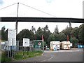
Old Kilpatrick recycling centre
Waste disposal facility near the site of the old Erskine Ferry with the Erskine Bridge in the background.
Image: © Richard Webb
Taken: 1 Sep 2009
0.06 miles
5
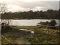
Erskine Ferry
The slip for the vehicle ferry across the Clyde that was replaced by the Erskine Bridge. The bridge opened and ferry closed in 1971.
Image: © Richard Webb
Taken: 1 Sep 2009
0.06 miles
6
Scout HQ
It's difficult to tell if this building is still in use as the 1st Glen Lusset Old Kilpatrick Scout Group HQ as the sign is quite faded.
Image: © Thomas Nugent
Taken: 7 Aug 2010
0.07 miles
7
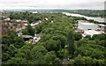
View from the Erskine Bridge
The old swing bridge over the Forth & Clyde Canal used to give access to the Erskine Ferry on the banks of the River Clyde. The white house beside the bridge is the late 18th century Bridge Keeper's Cottage. The buildings on the right are part of Subsea 7, a Global Pipeline Welding Development Centre.
Image: © Richard Sutcliffe
Taken: 29 Jul 2018
0.07 miles
8
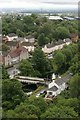
Old swing bridge over the Forth & Clyde Canal
The swing bridge over the canal used to give access to the Erskine Ferry on the banks of the River Clyde. The white house beside the bridge is the late 18th century Bridge Keeper's Cottage. Seen from the Erskine Bridge.
Image: © Richard Sutcliffe
Taken: 29 Jul 2018
0.07 miles
9
Dumbarton Road from the Erskine Bridge
The view from the bridge here is partially obscured by a grating with small circular holes - making photography difficult.
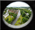
Image: © Richard Sutcliffe
Taken: 29 Jul 2018
0.07 miles
10
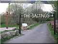
The Saltings
Local nature reserve beneath the Erskine Bridge in Old Kilpatrick.
Image: © Stephen Sweeney
Taken: 20 Apr 2009
0.07 miles