IMAGES TAKEN NEAR TO
Dumbarton Road, GLASGOW, G60 5AY
Introduction
This page details the photographs taken nearby to Dumbarton Road, G60 5AY by members of the Geograph project.
The Geograph project started in 2005 with the aim of publishing, organising and preserving representative images for every square kilometre of Great Britain, Ireland and the Isle of Man.

There are currently over 7.5m images from over14,400 individuals and you can help contribute to the project by visiting https://www.geograph.org.uk
Image Map
Images are licensed for reuse under creativecommons.org/licenses/by-sa/2.0
Notes
- Clicking on the map will re-center to the selected point.
- The higher the marker number, the further away the image location is from the centre of the postcode.
Image Listing (149 Images Found)
Images are licensed for reuse under creativecommons.org/licenses/by-sa/2.0
Image
Details
Distance
1
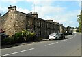
Auchentorlie Terrace
Terraced houses on Dumbarton Road.
Image: © Richard Sutcliffe
Taken: 1 Sep 2023
0.01 miles
2
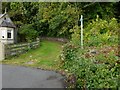
Former driveway to Auchentorlie House
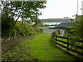
The picture was taken from the point where this path starts, alongside Dumbarton Road in Bowling (see Image, a view in the opposite direction along the same part of the route).
As indicated by the sign on the right, the path is a Right of Way. I have shown only a small part of the house on the left, since it is still in use as a private dwelling, but it has the appearance of a lodge, and that is exactly what it was. The presence of a former lodge is explained by the fact that this path was originally a driveway leading to Auchentorlie House.
For a view from a little further along the same path, see Image; as explained there, considerable labour must have been expended in creating the driveway. The path passes over the top of a tunnel; the tunnel dates from 1895 (Image), and is an essential component of the driveway, which therefore dates from the same period.
Image: © Lairich Rig
Taken: 28 Sep 2012
0.04 miles
3
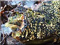
A fungus - Peroneutypa scoparia
Only a short distance east from the point from which the photograph Image was taken, a piece of fallen wood bore the unusual fungus shown here. The photograph shows one end of the piece of wood, which was 6cm thick, and about 30cm long; it is just one remaining fragment of a much larger piece, on which I first photographed the fungus, early in 2007: Image
The fungus is now darkened with age, but it was originally a fairly dark brown, rather than black. Each of the small individual structures consists of several finger-like projections extending from an irregular but more or less rounded base.
Image: © Lairich Rig
Taken: 5 Feb 2010
0.04 miles
4
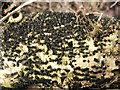
A fungus - Peroneutypa scoparia
For further information, see Image, which was taken in the same place about three years later. In the present picture, the fungus presents a more typical appearance.
It was growing on a piece of wood at the side of a cycle path in a deep, shaded cutting, formerly the route of a railway line: Image
Image: © Lairich Rig
Taken: 30 Mar 2007
0.04 miles
5
Former driveway from Auchentorlie House
This is a view along the lower end of a right of way in Bowling. Just ahead, the path ends beside Dumbarton Road, the main road through the village.
The path that the right of way follows was originally formed, in the late nineteenth century, as a driveway leading to Auchentorlie House. For more information, see Image, which is a view in the opposite direction along the same section of the path.
See Image for another part of the same route.
Image: © Lairich Rig
Taken: 28 Sep 2012
0.04 miles
6
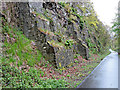
National Cycle Network Route 7 at Bowling
Buttresses holding up the rockface in the cutting at Bowling tunnel.
Image: © Thomas Nugent
Taken: 27 Apr 2015
0.04 miles
7
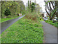
Site of Lanarkshire and Dunbartonshire Railway Bowling station
On what is now National Cycle Network Route 7.
Image: © Thomas Nugent
Taken: 27 Apr 2015
0.05 miles
8
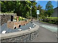
Scott Avenue, Bowling
The view is from the junction with Dumbarton Road. Indistinctly visible behind the tree furthest to the right is the structure shown in Image
There is a small plaque on the front of the train-themed planters: "Named by the community / THE BOWLING LASS / 12 August 2017".
Image: © Lairich Rig
Taken: 13 May 2018
0.05 miles
9
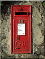
Post box in Bowling
GR postbox on Dumbarton Road, near the railway station.
Image: © Thomas Nugent
Taken: 2 Mar 2008
0.05 miles
10
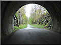
National Cycle Network Route 7 at Bowling
Looking east from within Bowling tunnel on the former Lanarkshire and Dunbartonshire Railway line.
Image: © Thomas Nugent
Taken: 27 Apr 2015
0.05 miles